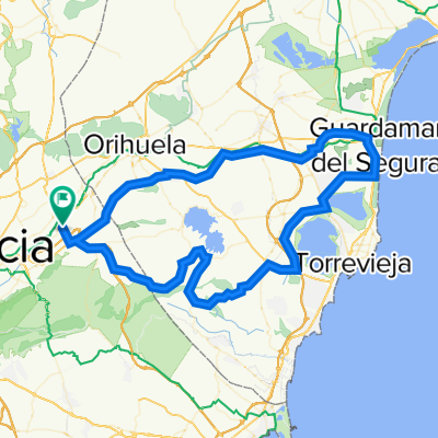
ruta por la costa mediterranea
A cycling route starting in Beniel, Murcia, Spain.
Overview
About this route
ALQUERIAS, LOS RAMOS, TORREAGUERA, BENIAJAN, SAN JOSE, ALTO DEL GARRUCAL, LOS MARTINEZ DEL PUERTO, EL JIMENADO, TORRE PACHECO, LOS ALCAZARES, LOS NAREJOS, SAN JAVIER, SAN PEDRO DEL PINATAR, PILAR DE LA HORADADA, EL PINAR DE CAMPOVERDE, LOS PILONES, TORREMENDO, FUENTE AMARGA, ALQUERIAS, 111,66 KLM.
- -:--
- Duration
- 111.7 km
- Distance
- 527 m
- Ascent
- 529 m
- Descent
- ---
- Avg. speed
- ---
- Avg. speed
Route quality
Waytypes & surfaces along the route
Waytypes
Busy road
57.7 km
(52 %)
Quiet road
30 km
(27 %)
Surfaces
Paved
29.9 km
(27 %)
Unpaved
0.5 km
(<1 %)
Asphalt
29.5 km
(26 %)
Unpaved (undefined)
0.4 km
(<1 %)
Continue with Bikemap
Use, edit, or download this cycling route
You would like to ride ruta por la costa mediterranea or customize it for your own trip? Here is what you can do with this Bikemap route:
Free features
- Save this route as favorite or in collections
- Copy & plan your own version of this route
- Sync your route with Garmin or Wahoo
Premium features
Free trial for 3 days, or one-time payment. More about Bikemap Premium.
- Navigate this route on iOS & Android
- Export a GPX / KML file of this route
- Create your custom printout (try it for free)
- Download this route for offline navigation
Discover more Premium features.
Get Bikemap PremiumFrom our community
Other popular routes starting in Beniel
- ESTACION DE BLANCA
- Distance
- 97.6 km
- Ascent
- 497 m
- Descent
- 496 m
- Location
- Beniel, Murcia, Spain
- TRES EMBALSES
- Distance
- 110.1 km
- Ascent
- 673 m
- Descent
- 677 m
- Location
- Beniel, Murcia, Spain
- LA PINILLA
- Distance
- 140.1 km
- Ascent
- 600 m
- Descent
- 600 m
- Location
- Beniel, Murcia, Spain
- PUERTO FRIO POR DETRAS
- Distance
- 102.5 km
- Ascent
- 916 m
- Descent
- 917 m
- Location
- Beniel, Murcia, Spain
- ALQUERIAS -MALECÓN 28 MAYO
- Distance
- 19.3 km
- Ascent
- 43 m
- Descent
- 44 m
- Location
- Beniel, Murcia, Spain
- GUARDAMAR, TORREVIEJA, EL PILAR
- Distance
- 113 km
- Ascent
- 446 m
- Descent
- 445 m
- Location
- Beniel, Murcia, Spain
- ruta por la costa mediterranea
- Distance
- 111.7 km
- Ascent
- 527 m
- Descent
- 529 m
- Location
- Beniel, Murcia, Spain
- GENOVINOS-GARRUCHAL-CRESTA DEL GALLO-CRESTA-GARRUCHAL-GENOVINOS-ANTENAS DE HURCHILLO
- Distance
- 158.4 km
- Ascent
- 1,217 m
- Descent
- 1,218 m
- Location
- Beniel, Murcia, Spain