Alzira Casella Simat PassLlop Alzira IBP60
- 47.8 km
- 560 m
- 560 m
- Alzira, Valencia, Spain
A cycling route starting in Alzira, Valencia, Spain.
Overview
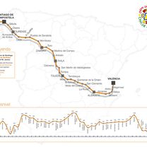
Difficulty: 3Category: 3 Castello-Bicorp-Alcudia-Alberic
Place Distance Altitude
Alzira (09:19:34) 1,93 km 22 hm
Carcaixent (09:23:35) 3,82 km 24 hm
Castelló (09:42:23) 13,04 km 30 hm
Alcantera (10:13:06) 18,81 km 34 hm
Rotonda Sellent (10:21:41) 22,54 km 50 hm
Sumacarcer (10:32:15) 27,82 km 47 hm
Alto de Sumacarcer (10:46:42) 31,45 km 260 hm
Navarres (11:03:03) 37,48 km 255 hm
Quesa (11:16:49) 42,90 km 210 hm
Alto de Bicorp (11:34:33) 47,83 km 284 hm
Quesa (11:44:40) 52,28 km 195 hm
Alto de Quesa (11:50:55) 53,89 km 258 hm
Navarres (11:59:23) 57,60 km 243 hm
Bolbaite (12:10:11) 62,05 km 246 hm
Chella (12:14:08) 64,54 km 186 hm
Anna (12:17:22) 66,41 km 194 hm
Alcudia de C (12:36:19) 77,27 km 138 hm
Cerdá (12:44:23) 79,50 km 119 hm
Vallés (12:52:15) 83,59 km 84 hm
Manuel (13:09:14) 92,35 km 40 hm
Castelló (13:14:26) 95,10 km 31 hm
Cruce Pobla (13:26:01) 99,84 km 23 hm
Alberic (13:29:32) 101,54 km 22 hm
Benimuslem (13:36:09) 104,74 km 21 hm
Alzira (13:45:18) 109,25 km 22 hm
created this 13 years ago
Route quality
Road
38.3 km
(34 %)
Quiet road
14.7 km
(13 %)
Paved
41.7 km
(37 %)
Asphalt
41.7 km
(37 %)
Undefined
71 km
(63 %)
Route highlights

Distancia:3,62 kms Porcentaje:5,9% Desnivel:215 mts Coeficiente:48 Pendiente maxima:10% Categoría: 1ª


Distancia:2,59 kms Porcentaje:5,8% Desnivel:150 mts Coeficiente:30 Pendiente maxima:12% Categoría: 2ª

l´Olivera punto de salida de la Penya CC Villanueva de Castellon
Continue with Bikemap
You would like to ride Castello-Bicorp-Alcudia C.-Alberic or customize it for your own trip? Here is what you can do with this Bikemap route:
Free trial for 3 days, or one-time payment. More about Bikemap Premium.
Discover more Premium features.
Get Bikemap PremiumFrom our community
Open it in the app