

南アルプス北回りコース
A cycling route starting in Ryūō, Yamanashi, Japan.
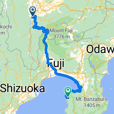
Overview
About this route
- -:--
- Duration
- 22.5 km
- Distance
- 252 m
- Ascent
- 254 m
- Descent
- ---
- Avg. speed
- 525 m
- Max. altitude

Continue with Bikemap
Use, edit, or download this cycling route
You would like to ride 南アルプス北回りコース or customize it for your own trip? Here is what you can do with this Bikemap route:
Free features
- Save this route as favorite or in collections
- Copy & plan your own version of this route
- Sync your route with Garmin or Wahoo
Premium features
Free trial for 3 days, or one-time payment. More about Bikemap Premium.
- Navigate this route on iOS & Android
- Export a GPX / KML file of this route
- Create your custom printout (try it for free)
- Download this route for offline navigation
Discover more Premium features.
Get Bikemap PremiumFrom our community
Other popular routes starting in Ryūō
 Kushigatayama-8/31/2013
- Distance
- 29.3 km
- Ascent
- 561 m
- Descent
- 561 m
- Location
- Ryūō, Yamanashi, Japan
 idoubi
- Distance
- 139.7 km
- Ascent
- 1,408 m
- Descent
- 1,632 m
- Location
- Ryūō, Yamanashi, Japan
 day3 大平洋から日本海へ
- Distance
- 94.7 km
- Ascent
- 896 m
- Descent
- 621 m
- Location
- Ryūō, Yamanashi, Japan
 南アルプス北回りコース
- Distance
- 22.5 km
- Ascent
- 252 m
- Descent
- 254 m
- Location
- Ryūō, Yamanashi, Japan
 神之湯溫泉往松本車站
- Distance
- 93.8 km
- Ascent
- 964 m
- Descent
- 688 m
- Location
- Ryūō, Yamanashi, Japan
 南アルプス南回りコース
- Distance
- 31.5 km
- Ascent
- 277 m
- Descent
- 280 m
- Location
- Ryūō, Yamanashi, Japan
 Kofu to Fuji
- Distance
- 80.2 km
- Ascent
- 357 m
- Descent
- 624 m
- Location
- Ryūō, Yamanashi, Japan
 みたまの湯 -河口湖 via 芦川
- Distance
- 33 km
- Ascent
- 1,281 m
- Descent
- 811 m
- Location
- Ryūō, Yamanashi, Japan
Open it in the app