sopo la calera y viceversa
A cycling route starting in Sopó, Cundinamarca, Colombia.
Overview
About this route
- 3 h 42 min
- Duration
- 53.9 km
- Distance
- 522 m
- Ascent
- 573 m
- Descent
- 14.5 km/h
- Avg. speed
- 2,740 m
- Avg. speed
Route photos
Route quality
Waytypes & surfaces along the route
Waytypes
Busy road
46.8 km
(87 %)
Access road
3.9 km
(7 %)
Surfaces
Paved
26.9 km
(50 %)
Unpaved
0.1 km
(<1 %)
Asphalt
24 km
(44 %)
Paved (undefined)
3 km
(6 %)
Continue with Bikemap
Use, edit, or download this cycling route
You would like to ride sopo la calera y viceversa or customize it for your own trip? Here is what you can do with this Bikemap route:
Free features
- Save this route as favorite or in collections
- Copy & plan your own version of this route
- Sync your route with Garmin or Wahoo
Premium features
Free trial for 3 days, or one-time payment. More about Bikemap Premium.
- Navigate this route on iOS & Android
- Export a GPX / KML file of this route
- Create your custom printout (try it for free)
- Download this route for offline navigation
Discover more Premium features.
Get Bikemap PremiumFrom our community
Other popular routes starting in Sopó
- rutica diaria
- Distance
- 18.1 km
- Ascent
- 135 m
- Descent
- 139 m
- Location
- Sopó, Cundinamarca, Colombia
- BRICEÑO - TOCANCIPA - PEAJE -TOCANCIPA -LA CARO - BRICEÑO
- Distance
- 60.2 km
- Ascent
- 79 m
- Descent
- 82 m
- Location
- Sopó, Cundinamarca, Colombia
- sopo la calera y viceversa
- Distance
- 53.9 km
- Ascent
- 522 m
- Descent
- 573 m
- Location
- Sopó, Cundinamarca, Colombia
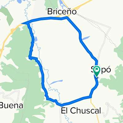
- Long ride through Guasca
- Distance
- 37.8 km
- Ascent
- 590 m
- Descent
- 589 m
- Location
- Sopó, Cundinamarca, Colombia
- Pionono
- Distance
- 4 km
- Ascent
- 568 m
- Descent
- 39 m
- Location
- Sopó, Cundinamarca, Colombia
- De Carrera 3 2 - 83, Sopo a Avenida Boyacá 64a29, Bogotá
- Distance
- 41.9 km
- Ascent
- 102 m
- Descent
- 148 m
- Location
- Sopó, Cundinamarca, Colombia
- Sopo Guatavita
- Distance
- 31.1 km
- Ascent
- 358 m
- Descent
- 204 m
- Location
- Sopó, Cundinamarca, Colombia
- Etapa 13 (Sopó - Tunja)
- Distance
- 114.1 km
- Ascent
- 1,092 m
- Descent
- 883 m
- Location
- Sopó, Cundinamarca, Colombia
Open it in the app