
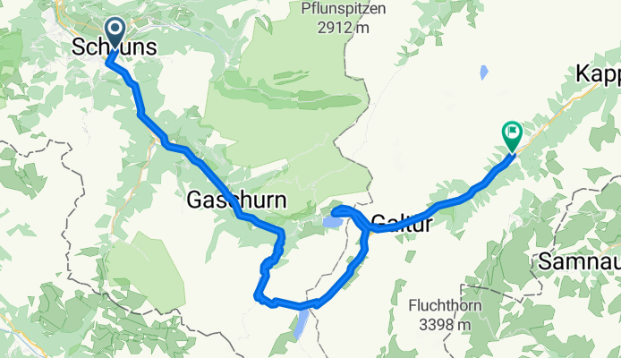
Silvretta-Hochalpenstrasse
A cycling route starting in Schruns, Vorarlberg, Austria.
Overview
About this route
- -:--
- Duration
- 61.7 km
- Distance
- 1,727 m
- Ascent
- 1,065 m
- Descent
- ---
- Avg. speed
- 2,036 m
- Avg. speed
Route quality
Waytypes & surfaces along the route
Waytypes
Track
16.6 km
(27 %)
Busy road
15.6 km
(25 %)
Surfaces
Paved
57.2 km
(93 %)
Unpaved
4.3 km
(7 %)
Asphalt
57 km
(92 %)
Gravel
4.3 km
(7 %)
Continue with Bikemap
Use, edit, or download this cycling route
You would like to ride Silvretta-Hochalpenstrasse or customize it for your own trip? Here is what you can do with this Bikemap route:
Free features
- Save this route as favorite or in collections
- Copy & plan your own version of this route
- Sync your route with Garmin or Wahoo
Premium features
Free trial for 3 days, or one-time payment. More about Bikemap Premium.
- Navigate this route on iOS & Android
- Export a GPX / KML file of this route
- Create your custom printout (try it for free)
- Download this route for offline navigation
Discover more Premium features.
Get Bikemap PremiumFrom our community
Other popular routes starting in Schruns
 M3 - extrem Montafon Mountainbike Marathon // Teilstrecken nur am Renntag befahrbar!
- Distance
- 134.5 km
- Ascent
- 4,344 m
- Descent
- 4,342 m
- Location
- Schruns, Vorarlberg, Austria
 schruns partenen heilbronner hütte silbertal schruns
- Distance
- 75.8 km
- Ascent
- 2,255 m
- Descent
- 2,258 m
- Location
- Schruns, Vorarlberg, Austria
 Vandans - Schweizer Tor - Lindauer Hütte
- Distance
- 35.4 km
- Ascent
- 1,680 m
- Descent
- 1,687 m
- Location
- Schruns, Vorarlberg, Austria
 Silvretta-Hochalpenstraße und Arlbergpaß RR
- Distance
- 138.8 km
- Ascent
- 2,371 m
- Descent
- 2,371 m
- Location
- Schruns, Vorarlberg, Austria
 Tschagguns - Latschau - Vadans - Schruns
- Distance
- 24.6 km
- Ascent
- 984 m
- Descent
- 986 m
- Location
- Schruns, Vorarlberg, Austria
 Mein erster Alpenpass vom 17. August 2017
- Distance
- 157.3 km
- Ascent
- 4,742 m
- Descent
- 4,730 m
- Location
- Schruns, Vorarlberg, Austria
 2011_2_Vorarlberg-Tirol-Allgäu-Runde (BAFGOR)_Tschagguns - See
- Distance
- 74.9 km
- Ascent
- 1,398 m
- Descent
- 1,068 m
- Location
- Schruns, Vorarlberg, Austria
 Rund um den Itonskopf Tour
- Distance
- 24.4 km
- Ascent
- 1,319 m
- Descent
- 916 m
- Location
- Schruns, Vorarlberg, Austria
Open it in the app