

2007 (Excursión Cuenca)
A cycling route starting in Cuenca, Castille-La Mancha, Spain.
Overview
About this route
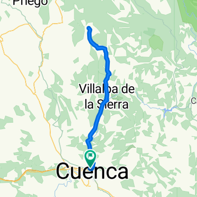
Nº 1 - Cuenca - Mariana - Collados - Pajares - Arcos de la Sierra - Portilla - Villalba de la Sierra - Pto. Ventano del Diablo - Uña - vuelta - Pto Ciudad Encantada - Valdecabras - Valdepino de Cuenca - Cuenca
- -:--
- Duration
- 105.9 km
- Distance
- 914 m
- Ascent
- 914 m
- Descent
- ---
- Avg. speed
- ---
- Max. altitude

Route quality
Waytypes & surfaces along the route
Waytypes
Road
44.5 km
(42 %)
Track
2.1 km
(2 %)
Surfaces
Paved
28.6 km
(27 %)
Unpaved
2.1 km
(2 %)
Asphalt
28.6 km
(27 %)
Gravel
2.1 km
(2 %)
Undefined
75.2 km
(71 %)
Route highlights
Points of interest along the route
Point of interest after 64 km
Pto. Ventano del Diablo
Point of interest after 65.9 km
Pto. Ciudad Encantada
Continue with Bikemap
Use, edit, or download this cycling route
You would like to ride 2007 (Excursión Cuenca) or customize it for your own trip? Here is what you can do with this Bikemap route:
Free features
- Save this route as favorite or in collections
- Copy & plan your own version of this route
- Split it into stages to create a multi-day tour
- Sync your route with Garmin or Wahoo
Premium features
Free trial for 3 days, or one-time payment. More about Bikemap Premium.
- Navigate this route on iOS & Android
- Export a GPX / KML file of this route
- Create your custom printout (try it for free)
- Download this route for offline navigation
Discover more Premium features.
Get Bikemap PremiumFrom our community
Other popular routes starting in Cuenca
 Carrera Montana de Jabaga en Bici
- Distance
- 51.9 km
- Ascent
- 811 m
- Descent
- 811 m
- Location
- Cuenca, Castille-La Mancha, Spain
 Cuenca - Cerro Sorroco - Palomera - Cuenca
- Distance
- 27.1 km
- Ascent
- 466 m
- Descent
- 465 m
- Location
- Cuenca, Castille-La Mancha, Spain
 Primer tramo Maraton "Sendas de Cuenca"
- Distance
- 37.7 km
- Ascent
- 668 m
- Descent
- 670 m
- Location
- Cuenca, Castille-La Mancha, Spain
 Cuenca - Fresneda de Altarejos - Mota - Valdeganga - Tórtola - Cuenca
- Distance
- 75.3 km
- Ascent
- 737 m
- Descent
- 707 m
- Location
- Cuenca, Castille-La Mancha, Spain
 Cuenca - Villalba - Fresneda - Villalba - Cuenca
- Distance
- 85.1 km
- Ascent
- 813 m
- Descent
- 790 m
- Location
- Cuenca, Castille-La Mancha, Spain
 Palomera, Buenache de la Sierra, Valdecabras.
- Distance
- 52.8 km
- Ascent
- 612 m
- Descent
- 613 m
- Location
- Cuenca, Castille-La Mancha, Spain
 Ruta de los Belenes de la senda de la Rambla
- Distance
- 49 km
- Ascent
- 754 m
- Descent
- 754 m
- Location
- Cuenca, Castille-La Mancha, Spain
 Cabeza Mosilla
- Distance
- 42.5 km
- Ascent
- 884 m
- Descent
- 884 m
- Location
- Cuenca, Castille-La Mancha, Spain
Open it in the app