

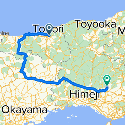
八頭・若桜周遊サイクリングコースマップ
A cycling route starting in Tottori-shi, Tottori, Japan.
Overview
About this route
- -:--
- Duration
- 44.2 km
- Distance
- 567 m
- Ascent
- 565 m
- Descent
- ---
- Avg. speed
- 215 m
- Max. altitude

Continue with Bikemap
Use, edit, or download this cycling route
You would like to ride 八頭・若桜周遊サイクリングコースマップ or customize it for your own trip? Here is what you can do with this Bikemap route:
Free features
- Save this route as favorite or in collections
- Copy & plan your own version of this route
- Sync your route with Garmin or Wahoo
Premium features
Free trial for 3 days, or one-time payment. More about Bikemap Premium.
- Navigate this route on iOS & Android
- Export a GPX / KML file of this route
- Create your custom printout (try it for free)
- Download this route for offline navigation
Discover more Premium features.
Get Bikemap PremiumFrom our community
Other popular routes starting in Tottori-shi
 Cycle Rural Japan - Hamamura to Misasa-onsen via Mitoku-san
- Distance
- 54.7 km
- Ascent
- 555 m
- Descent
- 507 m
- Location
- Tottori-shi, Tottori, Japan
 Hamasaka, Tottori a Kokubucho, Hamada
- Distance
- 240 km
- Ascent
- 2,530 m
- Descent
- 2,559 m
- Location
- Tottori-shi, Tottori, Japan
 Tottori to Kurashki
- Distance
- 145.2 km
- Ascent
- 2,360 m
- Descent
- 2,359 m
- Location
- Tottori-shi, Tottori, Japan
 鳥取砂丘 往 池田町
- Distance
- 362.8 km
- Ascent
- 2,597 m
- Descent
- 2,386 m
- Location
- Tottori-shi, Tottori, Japan
 鳥取駅/汽水空港/津山/西脇
- Distance
- 230.9 km
- Ascent
- 4,643 m
- Descent
- 4,594 m
- Location
- Tottori-shi, Tottori, Japan
 2017/3/14
- Distance
- 60.6 km
- Ascent
- 764 m
- Descent
- 761 m
- Location
- Tottori-shi, Tottori, Japan
 Torrori Sand Dunes ride
- Distance
- 72.2 km
- Ascent
- 2,421 m
- Descent
- 2,425 m
- Location
- Tottori-shi, Tottori, Japan
 After the road
- Distance
- 1,170 km
- Ascent
- 4,307 m
- Descent
- 4,287 m
- Location
- Tottori-shi, Tottori, Japan
Open it in the app