

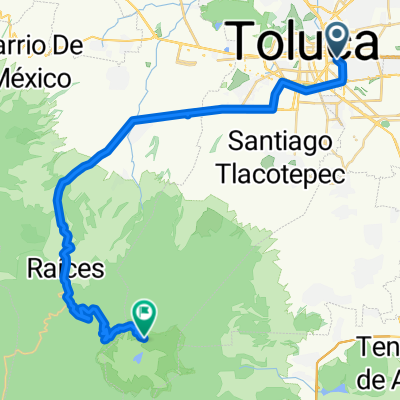
TLC - ALMOLOYA J - TLC
A cycling route starting in Toluca, State of Mexico, Mexico.
Overview
About this route
RUTA INTERMUNICPAL 12 DE FEBRERO DE 2012
- -:--
- Duration
- 61.9 km
- Distance
- 236 m
- Ascent
- 240 m
- Descent
- ---
- Avg. speed
- ---
- Max. altitude
Continue with Bikemap
Use, edit, or download this cycling route
You would like to ride TLC - ALMOLOYA J - TLC or customize it for your own trip? Here is what you can do with this Bikemap route:
Free features
- Save this route as favorite or in collections
- Copy & plan your own version of this route
- Sync your route with Garmin or Wahoo
Premium features
Free trial for 3 days, or one-time payment. More about Bikemap Premium.
- Navigate this route on iOS & Android
- Export a GPX / KML file of this route
- Create your custom printout (try it for free)
- Download this route for offline navigation
Discover more Premium features.
Get Bikemap PremiumFrom our community
Other popular routes starting in Toluca
 r165 ROAM
- Distance
- 144.2 km
- Ascent
- 959 m
- Descent
- 1,576 m
- Location
- Toluca, State of Mexico, Mexico
 Lerma aereopuerto
- Distance
- 8.9 km
- Ascent
- 3 m
- Descent
- 67 m
- Location
- Toluca, State of Mexico, Mexico
 toluca- nevado
- Distance
- 45.1 km
- Ascent
- 1,517 m
- Descent
- 12 m
- Location
- Toluca, State of Mexico, Mexico
 De Calle Paseo Tollocan Loc. 340, Toluca de Lerdo a Avenida Lic. Benito Juárez 23, San Mateo Atenco
- Distance
- 11.2 km
- Ascent
- 25 m
- Descent
- 81 m
- Location
- Toluca, State of Mexico, Mexico
 De Galileo Galilei 110, Toluca de Lerdo a Calle Ignacio López Rayón 100, San Mateo Otzacatipan
- Distance
- 6.3 km
- Ascent
- 6 m
- Descent
- 38 m
- Location
- Toluca, State of Mexico, Mexico
 Ruta de descanso
- Distance
- 24.1 km
- Ascent
- 115 m
- Descent
- 160 m
- Location
- Toluca, State of Mexico, Mexico
 Carrera tlu
- Distance
- 18.5 km
- Ascent
- 85 m
- Descent
- 37 m
- Location
- Toluca, State of Mexico, Mexico
 De Calle Prolongacion de Marzo a Nicolás Bravo
- Distance
- 11.9 km
- Ascent
- 285 m
- Descent
- 299 m
- Location
- Toluca, State of Mexico, Mexico
Open it in the app