

Bangkok Laos Cambodja ronde via Mekong
A cycling route starting in Chachoengsao, Chachoengsao, Thailand.
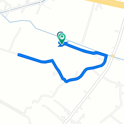
Overview
About this route
- -:--
- Duration
- 2,219.5 km
- Distance
- 2,665 m
- Ascent
- 2,507 m
- Descent
- ---
- Avg. speed
- 275 m
- Max. altitude

Continue with Bikemap
Use, edit, or download this cycling route
You would like to ride Bangkok Laos Cambodja ronde via Mekong or customize it for your own trip? Here is what you can do with this Bikemap route:
Free features
- Save this route as favorite or in collections
- Copy & plan your own version of this route
- Split it into stages to create a multi-day tour
- Sync your route with Garmin or Wahoo
Premium features
Free trial for 3 days, or one-time payment. More about Bikemap Premium.
- Navigate this route on iOS & Android
- Export a GPX / KML file of this route
- Create your custom printout (try it for free)
- Download this route for offline navigation
Discover more Premium features.
Get Bikemap PremiumFrom our community
Other popular routes starting in Chachoengsao
 natta 11Div#2
- Distance
- 57.7 km
- Ascent
- 12 m
- Descent
- 14 m
- Location
- Chachoengsao, Chachoengsao, Thailand
 J085 – Vendredi 31 mars 2017 Ban Tin Pet – Lat Krabang
- Distance
- 41.7 km
- Ascent
- 10 m
- Descent
- 8 m
- Location
- Chachoengsao, Chachoengsao, Thailand
 1020 Thep Khunakon 8/2, Mueang Chachoengsao to Chunlanan, Mueang Chachoengsao
- Distance
- 3.5 km
- Ascent
- 4 m
- Descent
- 4 m
- Location
- Chachoengsao, Chachoengsao, Thailand
 chachoengsao trip
- Distance
- 50.7 km
- Ascent
- 29 m
- Descent
- 27 m
- Location
- Chachoengsao, Chachoengsao, Thailand
 KMOT training day
- Distance
- 129.6 km
- Ascent
- 51 m
- Descent
- 48 m
- Location
- Chachoengsao, Chachoengsao, Thailand
 Khlong Na, Mueang Chachoengsao to Khlong Na, Mueang Chachoengsao
- Distance
- 3.6 km
- Ascent
- 3 m
- Descent
- 7 m
- Location
- Chachoengsao, Chachoengsao, Thailand
 murrah farm in the rain (219 km)
- Distance
- 172.2 km
- Ascent
- 112 m
- Descent
- 114 m
- Location
- Chachoengsao, Chachoengsao, Thailand
 ตำบล คลองนา to ตำบล คลองนา
- Distance
- 32 km
- Ascent
- 122 m
- Descent
- 123 m
- Location
- Chachoengsao, Chachoengsao, Thailand
Open it in the app