

定峰峠と林道丸山線
A cycling route starting in Chichibu, Saitama, Japan.
Overview
About this route
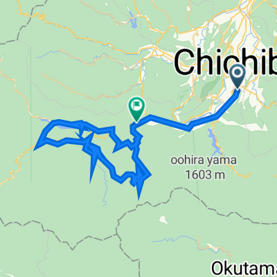
TABIRIN Download Distance: 40.3 km Minimum elevation: 193 m / Maximum elevation: 894 m Cumulative elevation (uphill): 1568 m / Cumulative elevation (downhill): 1567 m
- -:--
- Duration
- 40.3 km
- Distance
- 1,676 m
- Ascent
- 1,678 m
- Descent
- ---
- Avg. speed
- 896 m
- Max. altitude

Continue with Bikemap
Use, edit, or download this cycling route
You would like to ride 定峰峠と林道丸山線 or customize it for your own trip? Here is what you can do with this Bikemap route:
Free features
- Save this route as favorite or in collections
- Copy & plan your own version of this route
- Sync your route with Garmin or Wahoo
Premium features
Free trial for 3 days, or one-time payment. More about Bikemap Premium.
- Navigate this route on iOS & Android
- Export a GPX / KML file of this route
- Create your custom printout (try it for free)
- Download this route for offline navigation
Discover more Premium features.
Get Bikemap PremiumFrom our community
Other popular routes starting in Chichibu
 街なか札所巡り~その②~
- Distance
- 7.5 km
- Ascent
- 0 m
- Descent
- 0 m
- Location
- Chichibu, Saitama, Japan
 秩父サイクリング_城峯山
- Distance
- 67.3 km
- Ascent
- 1,148 m
- Descent
- 1,148 m
- Location
- Chichibu, Saitama, Japan
 20240330_花桃の郷&彩の国ふれあい牧場 etc桃源郷
- Distance
- 55.9 km
- Ascent
- 2,582 m
- Descent
- 2,581 m
- Location
- Chichibu, Saitama, Japan
 100 小鹿野歌舞伎・龍勢を回るルート
- Distance
- 44.5 km
- Ascent
- 920 m
- Descent
- 920 m
- Location
- Chichibu, Saitama, Japan
 大血川ライド
- Distance
- 67.9 km
- Ascent
- 3,240 m
- Descent
- 3,140 m
- Location
- Chichibu, Saitama, Japan
 20240426_2021 山岳サイクリング
- Distance
- 41.6 km
- Ascent
- 1,395 m
- Descent
- 1,398 m
- Location
- Chichibu, Saitama, Japan
 定峰峠-秩父高原牧場-寄居-小川町
- Distance
- 39.6 km
- Ascent
- 549 m
- Descent
- 1,081 m
- Location
- Chichibu, Saitama, Japan
 20090816 秩父札所巡礼三十一番~三十四番
- Distance
- 54.3 km
- Ascent
- 439 m
- Descent
- 606 m
- Location
- Chichibu, Saitama, Japan
Open it in the app