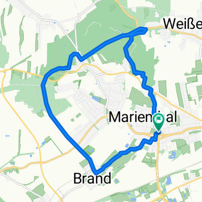
Mühltal
- 86.2 km
- 841 m
- 812 m
- Weißenborn, Saxony, Germany
A cycling route starting in Weißenborn, Saxony, Germany.
Overview
-suitable for the family ...(with conditions)
up to Brand along the bike path by the riding stable, then onto Lichtentanner Str. up to the roundabout, then turn right to Lidl, across the parking lot and the stream, then right past the youth hostel on the left side of the tracks (loose ground and gravel) through the underpass, then immediately left and on the right side of the tracks (very narrow) up to the garage courtyard, right turn, all the way down the street, turn right onto the 'Kleine Straße', on Bergstraße first asphalt, then meadow (here you can rest well) up to the slab path, then right up to the forest, about 30m straight ahead, and then left into the woods, follow the little path to B175, cross it and on the main path up to the 3 ponds ...
created this 16 years ago
Route quality
Track
4.6 km
(25 %)
Path
4.4 km
(24 %)
Paved
11.5 km
(62 %)
Unpaved
5.5 km
(30 %)
Asphalt
10.7 km
(58 %)
Gravel
2.4 km
(13 %)
Route highlights
- soooooooooo STEIL,aber die Pause ist NAH!
-ab hier ist nur Feld und Wiese bis zum Plattenweg (ca.500m)
- endlich Schatten und eine tolle Stelle neben Kühen und Pferden zu rasten, -Sicht bis ins Erzgebirge und das Vogtland
-sucht euch den Weg,manchmal findet man ihn :-)
-kann ab hier auch ´´Zum Fernblick´´ rechts abbiegen und den 2.Teil weglassen
Continue with Bikemap
You would like to ride von der Stadt aufs Land in den Wald und zurück or customize it for your own trip? Here is what you can do with this Bikemap route:
Free trial for 3 days, or one-time payment. More about Bikemap Premium.
Discover more Premium features.
Get Bikemap PremiumFrom our community
Open it in the app