
Kraichgau-Blick-Tour im Kraichgau-Stromberg
A cycling route starting in Eppingen, Baden-Wurttemberg, Germany.
Overview
About this route
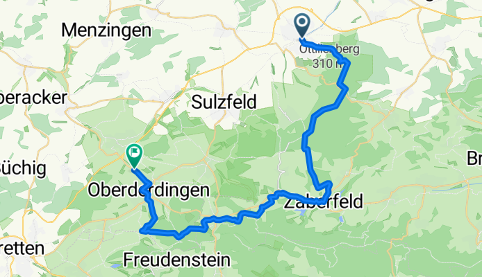
Eppingen – Oberderdingen 27.5 km
-
The tour starts in Eppingen at the train station. At the roundabout, take 'Theodor Storm Straße', continue on 'Waldstraße' past the stadium, out of Eppingen into the forest on the 'Hornbuckelweg' uphill to 'Schillerplatz'.
-
At the four-way junction at the height, turn right onto 'Richtweg'. At the T-junction, left, the next right, cross L1110 and continue straight past the hiking car park following the forest path at height.
-
At the four-way junction (Km 8.5) bear slightly left onto 'Plattenweg'. Follow the paved path along the forest edge straight downhill. At the four-way junction, continue straight now on gravel to the T-junction above the vineyard.
-
There turn left and downhill along the vineyard to Zaberfeld. Past the farm to the district road and right along it into the town.
-
At the stream, right and follow the farm road along the stream. Cross the main street and follow the cycle path to Leonbronn.
-
There left, steeply uphill on 'Ernst-Neubauer-Straße'. At the height, follow the road to the right and at the hiking car park turn left along the farm road. At the next fork right on the gravel road, at the T-junction left and straight into the forest.
-
In the forest first right onto the forest road to Sternenfels.On the main road left into the town and in the centre follow the priority turn right.
-
At the next fork bear slightly left and the next left into 'Schlattweg'. Over the saddle and past the vineyard straight downhill into the forest. Follow the hiking trail past the ponds(Attention: short section with poor surface).
-
At the four-way junction at 'Kraichsee' bear slightly left, along the lake and uphill. At the five-way junction right, continue uphill, then slightly left, past the barbecue hut and to the viewpoint'Derdinger Horn'.
-
Turn right and about 400 m downhill along the forest edge, then right onto the farm road and through the vineyard. At the T-junction left and straight into Oberderdingen.
Oberderdingen - Eppingen 16.5 km
-
On the main street right, then left towards Flehingen, at the priority bend bear slightly left into 'Rote Tor Straße', right into 'Haustraße' and at its end follow the main road left (the cycle path begins 300 m further) towards Flehingen.
-
At the roundabout past the petrol station, follow the cycle path slightly left uphill to the Flehingen train stop. Through the underpass, then right downhill to the main road. First straight, then left into the town centre. Left to the castle then right into 'Sam.-Fr. Sauter-Straße' and straight past the school.
-
Right into 'Bahnbrücker-Straße', next left ('Fr.-v.- Sickingen-Straße') and follow the connecting road to Zaisenhausen.
-
At the village entrance after the sports field, slightly left onto the gravel road and follow it along the edge of the village.
-
At the end of the village over the bridge on the cycle path and straight to Sulzfeld.
-
On the main street left and next right, straight past the sports field and along the farm road uphill through the vineyard. At height continue straight and soon downhill.
-
At the double junction in the valley straight, at 'Raußmühle' bear slightly right and follow the cycle tour route signs into Eppingen and back to the start point of the tour.
- -:--
- Duration
- 29.2 km
- Distance
- 390 m
- Ascent
- 405 m
- Descent
- ---
- Avg. speed
- ---
- Max. altitude

Route quality
Waytypes & surfaces along the route
Waytypes
Track
20.4 km
(70 %)
Quiet road
5 km
(17 %)
Surfaces
Paved
12 km
(41 %)
Unpaved
14.3 km
(49 %)
Asphalt
9.6 km
(33 %)
Gravel
8.8 km
(30 %)
Continue with Bikemap
Use, edit, or download this cycling route
You would like to ride Kraichgau-Blick-Tour im Kraichgau-Stromberg or customize it for your own trip? Here is what you can do with this Bikemap route:
Free features
- Save this route as favorite or in collections
- Copy & plan your own version of this route
- Sync your route with Garmin or Wahoo
Premium features
Free trial for 3 days, or one-time payment. More about Bikemap Premium.
- Navigate this route on iOS & Android
- Export a GPX / KML file of this route
- Create your custom printout (try it for free)
- Download this route for offline navigation
Discover more Premium features.
Get Bikemap PremiumFrom our community
Other popular routes starting in Eppingen
 einfach..
- Distance
- 28.4 km
- Ascent
- 83 m
- Descent
- 123 m
- Location
- Eppingen, Baden-Wurttemberg, Germany
 Route_1 (Eppingen)
- Distance
- 34.9 km
- Ascent
- 155 m
- Descent
- 155 m
- Location
- Eppingen, Baden-Wurttemberg, Germany
 von Eppingen zum Neckar durch Heidelberg nach Karlsruhe
- Distance
- 151 km
- Ascent
- 569 m
- Descent
- 654 m
- Location
- Eppingen, Baden-Wurttemberg, Germany
 RR von Eppingen zu den Schönheiten des Kraichgau
- Distance
- 62.6 km
- Ascent
- 598 m
- Descent
- 603 m
- Location
- Eppingen, Baden-Wurttemberg, Germany
 Kraichgau - Blick Tour
- Distance
- 44 km
- Ascent
- 419 m
- Descent
- 421 m
- Location
- Eppingen, Baden-Wurttemberg, Germany
 Elsenztal-Tour im Kraichgau-Stromberg
- Distance
- 38.7 km
- Ascent
- 55 m
- Descent
- 144 m
- Location
- Eppingen, Baden-Wurttemberg, Germany
 Tour de Stromberg
- Distance
- 63.1 km
- Ascent
- 837 m
- Descent
- 751 m
- Location
- Eppingen, Baden-Wurttemberg, Germany
 41 km Elsenz-Dühren-Angelbachtal
- Distance
- 41.8 km
- Ascent
- 282 m
- Descent
- 267 m
- Location
- Eppingen, Baden-Wurttemberg, Germany
Open it in the app