

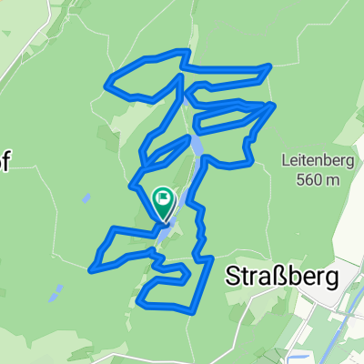
Höhenmeter-Trainingsrunde in den Stauden
A cycling route starting in Wehringen, Bavaria, Germany.
Overview
About this route
Training round with many steep climbs.
- -:--
- Duration
- 40.2 km
- Distance
- 600 m
- Ascent
- 600 m
- Descent
- ---
- Avg. speed
- ---
- Max. altitude
Route quality
Waytypes & surfaces along the route
Waytypes
Track
33 km
(82 %)
Road
2.4 km
(6 %)
Surfaces
Paved
6 km
(15 %)
Unpaved
34.2 km
(85 %)
Gravel
15.3 km
(38 %)
Loose gravel
12.9 km
(32 %)
Continue with Bikemap
Use, edit, or download this cycling route
You would like to ride Höhenmeter-Trainingsrunde in den Stauden or customize it for your own trip? Here is what you can do with this Bikemap route:
Free features
- Save this route as favorite or in collections
- Copy & plan your own version of this route
- Sync your route with Garmin or Wahoo
Premium features
Free trial for 3 days, or one-time payment. More about Bikemap Premium.
- Navigate this route on iOS & Android
- Export a GPX / KML file of this route
- Create your custom printout (try it for free)
- Download this route for offline navigation
Discover more Premium features.
Get Bikemap PremiumFrom our community
Other popular routes starting in Wehringen
 ww 30
ww 30- Distance
- 27.9 km
- Ascent
- 585 m
- Descent
- 582 m
- Location
- Wehringen, Bavaria, Germany
 von Bobingen zur Mickhauser Alm
- Distance
- 18.3 km
- Ascent
- 284 m
- Descent
- 230 m
- Location
- Wehringen, Bavaria, Germany
 Zum Kaffeetrinken nach Bad Wörishofen
- Distance
- 42.1 km
- Ascent
- 130 m
- Descent
- 4 m
- Location
- Wehringen, Bavaria, Germany
 O-schönKlein
- Distance
- 32.3 km
- Ascent
- 409 m
- Descent
- 408 m
- Location
- Wehringen, Bavaria, Germany
 Kapellentour
- Distance
- 31.3 km
- Ascent
- 321 m
- Descent
- 321 m
- Location
- Wehringen, Bavaria, Germany
 Auf den Spuren der Wildere
- Distance
- 29.5 km
- Ascent
- 425 m
- Descent
- 426 m
- Location
- Wehringen, Bavaria, Germany
 20170518_081234.gpx
- Distance
- 15.7 km
- Ascent
- 38 m
- Descent
- 58 m
- Location
- Wehringen, Bavaria, Germany
 Höhenmeter-Trainingsrunde in den Stauden
- Distance
- 40.2 km
- Ascent
- 600 m
- Descent
- 600 m
- Location
- Wehringen, Bavaria, Germany
Open it in the app