
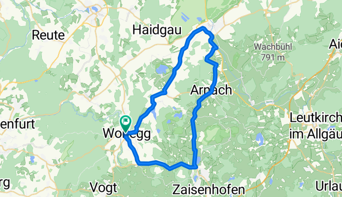
Feierabend Tour
A cycling route starting in Wolfegg, Baden-Wurttemberg, Germany.
Overview
About this route
- -:--
- Duration
- 37.5 km
- Distance
- 322 m
- Ascent
- 322 m
- Descent
- ---
- Avg. speed
- ---
- Max. altitude
Route quality
Waytypes & surfaces along the route
Waytypes
Busy road
29.4 km
(78 %)
Quiet road
3.7 km
(10 %)
Surfaces
Paved
27.6 km
(74 %)
Unpaved
0.1 km
(<1 %)
Asphalt
27.6 km
(74 %)
Unpaved (undefined)
0 km
(<1 %)
Continue with Bikemap
Use, edit, or download this cycling route
You would like to ride Feierabend Tour or customize it for your own trip? Here is what you can do with this Bikemap route:
Free features
- Save this route as favorite or in collections
- Copy & plan your own version of this route
- Sync your route with Garmin or Wahoo
Premium features
Free trial for 3 days, or one-time payment. More about Bikemap Premium.
- Navigate this route on iOS & Android
- Export a GPX / KML file of this route
- Create your custom printout (try it for free)
- Download this route for offline navigation
Discover more Premium features.
Get Bikemap PremiumFrom our community
Other popular routes starting in Wolfegg
 Wolfegg-Bad Waldsee- Eintürnen-Wlfegg 32
- Distance
- 34.7 km
- Ascent
- 345 m
- Descent
- 332 m
- Location
- Wolfegg, Baden-Wurttemberg, Germany
 Berg nach Berg 7/1
- Distance
- 70.8 km
- Ascent
- 726 m
- Descent
- 760 m
- Location
- Wolfegg, Baden-Wurttemberg, Germany
 Baindt Eintürnen hin und zurück
- Distance
- 14.7 km
- Ascent
- 133 m
- Descent
- 359 m
- Location
- Wolfegg, Baden-Wurttemberg, Germany
 zu Silvi
- Distance
- 16.9 km
- Ascent
- 45 m
- Descent
- 266 m
- Location
- Wolfegg, Baden-Wurttemberg, Germany
 Altann-Argental-Friedrichshafen
- Distance
- 62.4 km
- Ascent
- 670 m
- Descent
- 932 m
- Location
- Wolfegg, Baden-Wurttemberg, Germany
 Flowi Trails zur und von der Süh
- Distance
- 33 km
- Ascent
- 295 m
- Descent
- 296 m
- Location
- Wolfegg, Baden-Wurttemberg, Germany
 Radwallfahrt 2010
- Distance
- 25.4 km
- Ascent
- 267 m
- Descent
- 272 m
- Location
- Wolfegg, Baden-Wurttemberg, Germany
 wolfegg-wolfegg 65 km
- Distance
- 65.3 km
- Ascent
- 405 m
- Descent
- 400 m
- Location
- Wolfegg, Baden-Wurttemberg, Germany
Open it in the app