
Oder-Spree-Tour - Frankfurt (Oder) to Wiesenau
A cycling route starting in Frankfurt (Oder), Brandenburg, Germany.
Overview
About this route
More about Oder-Spree-Tour:
https://www.cyclingthread.com/oder-spree-tour-truly-cyclist-friendly-brandenburg
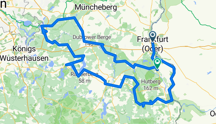
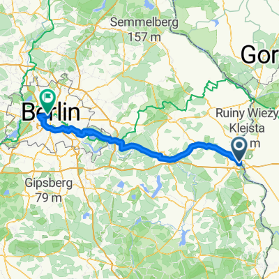
The Oder-Spree Tour is a circular route of about 278 km through the lakes, rivers, forests and canals of eastern Brandenburg. It usually takes around four days to complete and starts and ends in Frankfurt (Oder), not far from Berlin. Most of the way follows quiet bike paths and forest roads closed to car traffic, which makes the ride peaceful and safe. Only short sections run directly along the Oder and the Spree, while much of the route follows canals such as the Oder-Spree Canal and the Frederick William Canal. The scenery is a mix of woodlands, lakes and cultural sights like monasteries, medieval towns and canal locks. Highlights include Neuzelle Abbey, the old center of Beeskow, the spa town of Bad Saarow and several historic waterways. The route is flat, well signposted and supported by good train access, making it easy to adapt for shorter trips.
- -:--
- Duration
- 289.4 km
- Distance
- 1,362 m
- Ascent
- 1,357 m
- Descent
- ---
- Avg. speed
- 139 m
- Max. altitude

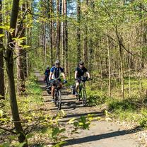
Route photos
 to Wiesenau\"")
 to Wiesenau\"")
 to Wiesenau\"")
 to Wiesenau\"")
Route quality
Waytypes & surfaces along the route
Waytypes
Path
101.3 km
(35 %)
Quiet road
95.5 km
(33 %)
Surfaces
Paved
231.5 km
(80 %)
Unpaved
5.8 km
(2 %)
Asphalt
219.9 km
(76 %)
Paved (undefined)
5.8 km
(2 %)
Continue with Bikemap
Use, edit, or download this cycling route
You would like to ride Oder-Spree-Tour - Frankfurt (Oder) to Wiesenau or customize it for your own trip? Here is what you can do with this Bikemap route:
Free features
- Save this route as favorite or in collections
- Copy & plan your own version of this route
- Split it into stages to create a multi-day tour
- Sync your route with Garmin or Wahoo
Premium features
Free trial for 3 days, or one-time payment. More about Bikemap Premium.
- Navigate this route on iOS & Android
- Export a GPX / KML file of this route
- Create your custom printout (try it for free)
- Download this route for offline navigation
Discover more Premium features.
Get Bikemap PremiumFrom our community
Other popular routes starting in Frankfurt (Oder)
 Frank.A.-Hafenstr.-Drzecin-Nowe-B.-Rybocice-Fra.
- Distance
- 41.9 km
- Ascent
- 137 m
- Descent
- 135 m
- Location
- Frankfurt (Oder), Brandenburg, Germany
 Frankfurt Oder schönes Umland
- Distance
- 60.9 km
- Ascent
- 175 m
- Descent
- 172 m
- Location
- Frankfurt (Oder), Brandenburg, Germany
 Rowerem dookoła POLSKI
- Distance
- 3,549.8 km
- Ascent
- 2,307 m
- Descent
- 2,307 m
- Location
- Frankfurt (Oder), Brandenburg, Germany
 Oder-Spree-Tour - Frankfurt (Oder) to Wiesenau
- Distance
- 289.4 km
- Ascent
- 1,362 m
- Descent
- 1,357 m
- Location
- Frankfurt (Oder), Brandenburg, Germany
 Duża Helena
- Distance
- 39.4 km
- Ascent
- 140 m
- Descent
- 140 m
- Location
- Frankfurt (Oder), Brandenburg, Germany
 durch das Schlaubetal
- Distance
- 46.4 km
- Ascent
- 186 m
- Descent
- 186 m
- Location
- Frankfurt (Oder), Brandenburg, Germany
 adfc Sternfahrt 2013 / 12. Route Frankfurt (Oder)
- Distance
- 111.5 km
- Ascent
- 158 m
- Descent
- 179 m
- Location
- Frankfurt (Oder), Brandenburg, Germany
 Straßentraining Bahnlehrgang
- Distance
- 43.1 km
- Ascent
- 164 m
- Descent
- 164 m
- Location
- Frankfurt (Oder), Brandenburg, Germany
Open it in the app