
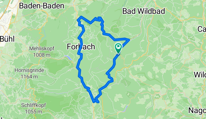
Enztal-Murgtal-Kaltenbronner Wand
A cycling route starting in Enzklösterle, Baden-Wurttemberg, Germany.
Overview
About this route
With the Kaltenbronner Wand an almost alpine ascent, 750 m of elevation over about 11 km.
- -:--
- Duration
- 64.3 km
- Distance
- 1,613 m
- Ascent
- 1,486 m
- Descent
- ---
- Avg. speed
- 846 m
- Max. altitude

Route quality
Waytypes & surfaces along the route
Waytypes
Road
8.4 km
(13 %)
Path
3.2 km
(5 %)
Surfaces
Paved
58.5 km
(91 %)
Unpaved
3.2 km
(5 %)
Asphalt
57.9 km
(90 %)
Gravel
1.3 km
(2 %)
Continue with Bikemap
Use, edit, or download this cycling route
You would like to ride Enztal-Murgtal-Kaltenbronner Wand or customize it for your own trip? Here is what you can do with this Bikemap route:
Free features
- Save this route as favorite or in collections
- Copy & plan your own version of this route
- Sync your route with Garmin or Wahoo
Premium features
Free trial for 3 days, or one-time payment. More about Bikemap Premium.
- Navigate this route on iOS & Android
- Export a GPX / KML file of this route
- Create your custom printout (try it for free)
- Download this route for offline navigation
Discover more Premium features.
Get Bikemap PremiumFrom our community
Other popular routes starting in Enzklösterle
 Enz und Eyach CLONED FROM ROUTE 245
- Distance
- 49.7 km
- Ascent
- 776 m
- Descent
- 776 m
- Location
- Enzklösterle, Baden-Wurttemberg, Germany
 Poppeltal-Schwarzenberg
- Distance
- 5.9 km
- Ascent
- 212 m
- Descent
- 343 m
- Location
- Enzklösterle, Baden-Wurttemberg, Germany
 Enz-Eyach-Rohnbach
- Distance
- 53.6 km
- Ascent
- 685 m
- Descent
- 685 m
- Location
- Enzklösterle, Baden-Wurttemberg, Germany
 Meistern - Überberg
- Distance
- 21.9 km
- Ascent
- 142 m
- Descent
- 336 m
- Location
- Enzklösterle, Baden-Wurttemberg, Germany
 Enztalradweg, Bad Wildbad, Grünhütte, Kaltenbronn, Hohlohturm, Gompelscheuer, Enztalquelle
- Distance
- 58 km
- Ascent
- 1,897 m
- Descent
- 1,887 m
- Location
- Enzklösterle, Baden-Wurttemberg, Germany
 Enz-Murg-Panorama
- Distance
- 45 km
- Ascent
- 737 m
- Descent
- 742 m
- Location
- Enzklösterle, Baden-Wurttemberg, Germany
 Enztal-Radweg: Quelle - Pforzheim
- Distance
- 46.3 km
- Ascent
- 176 m
- Descent
- 634 m
- Location
- Enzklösterle, Baden-Wurttemberg, Germany
 Schwarzwald-3__Enzklösterle-Besenfeld
- Distance
- 17.3 km
- Ascent
- 398 m
- Descent
- 163 m
- Location
- Enzklösterle, Baden-Wurttemberg, Germany
Open it in the app