

kopcovitý terén
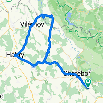
A cycling route starting in Chotěboř, Kraj Vysočina, Czechia.
Overview
About this route
A beautiful predominantly forest trail full of beautiful nature and views into the Iron Mountains valley.
- -:--
- Duration
- 23.8 km
- Distance
- 385 m
- Ascent
- 385 m
- Descent
- ---
- Avg. speed
- ---
- Max. altitude
Route quality
Waytypes & surfaces along the route
Waytypes
Road
14 km
(59 %)
Track
6.9 km
(29 %)
Surfaces
Paved
4 km
(17 %)
Unpaved
6.9 km
(29 %)
Unpaved (undefined)
4.3 km
(18 %)
Asphalt
4 km
(17 %)
Route highlights
Points of interest along the route
Point of interest after 4.3 km
Lánska lipa http://www.dedictvivysociny.cz/priroda/pamatne_stromy-14/?id=1747
Point of interest after 6.6 km
Lesní pramen čisté pitné vody
Point of interest after 7.9 km
Spálavská Lípa http://cs.wikipedia.org/wiki/Sp%C3%A1lavsk%C3%A1_l%C3%ADpa
Point of interest after 13.6 km
klokočovská Lípa http://wiki.mapy.cz/index.php/Kloko%C4%8Dovsk%C3%A1_l%C3%ADpa
Continue with Bikemap
Use, edit, or download this cycling route
You would like to ride kopcovitý terén or customize it for your own trip? Here is what you can do with this Bikemap route:
Free features
- Save this route as favorite or in collections
- Copy & plan your own version of this route
- Sync your route with Garmin or Wahoo
Premium features
Free trial for 3 days, or one-time payment. More about Bikemap Premium.
- Navigate this route on iOS & Android
- Export a GPX / KML file of this route
- Create your custom printout (try it for free)
- Download this route for offline navigation
Discover more Premium features.
Get Bikemap PremiumFrom our community
Other popular routes starting in Chotěboř
 OKOLO LIBICE 2015
- Distance
- 27.2 km
- Ascent
- 426 m
- Descent
- 425 m
- Location
- Chotěboř, Kraj Vysočina, Czechia
 Chotěboř - Lichnice- Lipnice nad Sázavou Chotěboř
- Distance
- 101 km
- Ascent
- 843 m
- Descent
- 840 m
- Location
- Chotěboř, Kraj Vysočina, Czechia
 Výlet Chotěboř - pařížovská přehrada a zpět
- Distance
- 59.9 km
- Ascent
- 417 m
- Descent
- 417 m
- Location
- Chotěboř, Kraj Vysočina, Czechia
 Libice - Boika
- Distance
- 41.1 km
- Ascent
- 641 m
- Descent
- 641 m
- Location
- Chotěboř, Kraj Vysočina, Czechia
 Jarní výlet údolím pod Železnýma horama
- Distance
- 26.7 km
- Ascent
- 292 m
- Descent
- 290 m
- Location
- Chotěboř, Kraj Vysočina, Czechia
 Ride to the Iron Mountains
- Distance
- 44.1 km
- Ascent
- 502 m
- Descent
- 503 m
- Location
- Chotěboř, Kraj Vysočina, Czechia
 Školní výlet 2
- Distance
- 21.8 km
- Ascent
- 283 m
- Descent
- 265 m
- Location
- Chotěboř, Kraj Vysočina, Czechia
 Libice - Bajkove uterky
- Distance
- 42 km
- Ascent
- 466 m
- Descent
- 466 m
- Location
- Chotěboř, Kraj Vysočina, Czechia
Open it in the app