

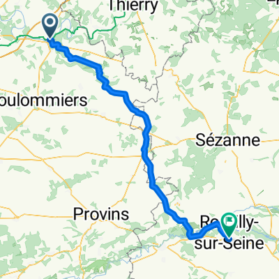
ballade avec les lenoir
A cycling route starting in La Ferté-sous-Jouarre, Île-de-France Region, France.
Overview
About this route
- -:--
- Duration
- 20.6 km
- Distance
- 221 m
- Ascent
- 221 m
- Descent
- ---
- Avg. speed
- ---
- Max. altitude

Route quality
Waytypes & surfaces along the route
Waytypes
Road
7.4 km
(36 %)
Quiet road
6.4 km
(31 %)
Surfaces
Paved
2.3 km
(11 %)
Unpaved
0.4 km
(2 %)
Asphalt
2.3 km
(11 %)
Ground
0.4 km
(2 %)
Undefined
17.9 km
(87 %)
Route highlights
Points of interest along the route
Point of interest after 0 km
Continue with Bikemap
Use, edit, or download this cycling route
You would like to ride ballade avec les lenoir or customize it for your own trip? Here is what you can do with this Bikemap route:
Free features
- Save this route as favorite or in collections
- Copy & plan your own version of this route
- Sync your route with Garmin or Wahoo
Premium features
Free trial for 3 days, or one-time payment. More about Bikemap Premium.
- Navigate this route on iOS & Android
- Export a GPX / KML file of this route
- Create your custom printout (try it for free)
- Download this route for offline navigation
Discover more Premium features.
Get Bikemap PremiumFrom our community
Other popular routes starting in La Ferté-sous-Jouarre
 La Ferté sous Jouarre/Saulny
- Distance
- 294 km
- Ascent
- 674 m
- Descent
- 499 m
- Location
- La Ferté-sous-Jouarre, Île-de-France Region, France
 La Ferté-Sous-Jouarre - Chateau Thierry
- Distance
- 64.3 km
- Ascent
- 261 m
- Descent
- 255 m
- Location
- La Ferté-sous-Jouarre, Île-de-France Region, France
 La Ferte sous Jouarre - Paris
- Distance
- 85 km
- Ascent
- 213 m
- Descent
- 224 m
- Location
- La Ferté-sous-Jouarre, Île-de-France Region, France
 etapa 13
- Distance
- 71.3 km
- Ascent
- 173 m
- Descent
- 176 m
- Location
- La Ferté-sous-Jouarre, Île-de-France Region, France
 BFP2020_05_10_Nr04_Chateau_Thierry_Chalons_Sur_Marne
- Distance
- 150.5 km
- Ascent
- 1,197 m
- Descent
- 1,271 m
- Location
- La Ferté-sous-Jouarre, Île-de-France Region, France
 day 2 trip
- Distance
- 89.7 km
- Ascent
- 725 m
- Descent
- 706 m
- Location
- La Ferté-sous-Jouarre, Île-de-France Region, France
 sortie du 4 fervier 2011
- Distance
- 99.6 km
- Ascent
- 445 m
- Descent
- 444 m
- Location
- La Ferté-sous-Jouarre, Île-de-France Region, France
 saletée de charière
- Distance
- 32.1 km
- Ascent
- 379 m
- Descent
- 379 m
- Location
- La Ferté-sous-Jouarre, Île-de-France Region, France
Open it in the app