
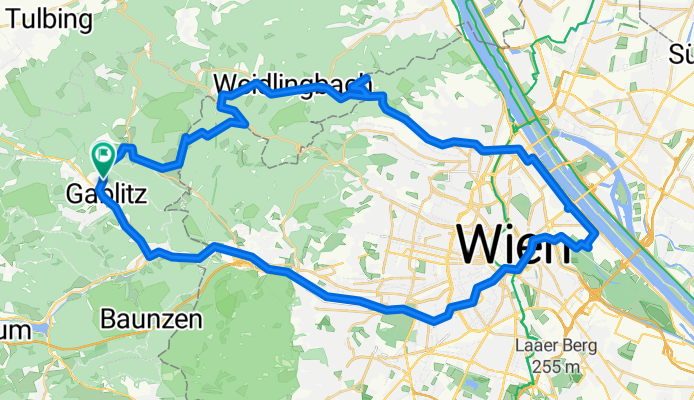
Gablitz - Herrmannskogel - Prater - Vienna City - Schoenbrunn - Gablitz
A cycling route starting in Gablitz, Lower Austria, Austria.
Overview
About this route
- 2 h 51 min
- Duration
- 60.5 km
- Distance
- 968 m
- Ascent
- 973 m
- Descent
- 21.2 km/h
- Avg. speed
- 543 m
- Max. altitude

Route photos


Route quality
Waytypes & surfaces along the route
Waytypes
Busy road
16.1 km
(27 %)
Quiet road
10.7 km
(18 %)
Surfaces
Paved
40.3 km
(67 %)
Unpaved
10.9 km
(18 %)
Asphalt
36.3 km
(60 %)
Gravel
6.6 km
(11 %)
Continue with Bikemap
Use, edit, or download this cycling route
You would like to ride Gablitz - Herrmannskogel - Prater - Vienna City - Schoenbrunn - Gablitz or customize it for your own trip? Here is what you can do with this Bikemap route:
Free features
- Save this route as favorite or in collections
- Copy & plan your own version of this route
- Sync your route with Garmin or Wahoo
Premium features
Free trial for 3 days, or one-time payment. More about Bikemap Premium.
- Navigate this route on iOS & Android
- Export a GPX / KML file of this route
- Create your custom printout (try it for free)
- Download this route for offline navigation
Discover more Premium features.
Get Bikemap PremiumFrom our community
Other popular routes starting in Gablitz
 Gablitz - Herrmannskogel - Prater - Vienna City - Schoenbrunn - Gablitz
- Distance
- 60.5 km
- Ascent
- 968 m
- Descent
- 973 m
- Location
- Gablitz, Lower Austria, Austria
 Gablitz Round
- Distance
- 20.9 km
- Ascent
- 490 m
- Descent
- 486 m
- Location
- Gablitz, Lower Austria, Austria
 Gablitz - Troppberg - Irenental - Riederberg - Tulbingerkogel
- Distance
- 34.6 km
- Ascent
- 1,042 m
- Descent
- 1,016 m
- Location
- Gablitz, Lower Austria, Austria
 Hirschengarten I
- Distance
- 14.1 km
- Ascent
- 238 m
- Descent
- 187 m
- Location
- Gablitz, Lower Austria, Austria
 Wienerwald / Gablitz / Mirli / Tullnerbach / Troppberg
- Distance
- 30.9 km
- Ascent
- 944 m
- Descent
- 941 m
- Location
- Gablitz, Lower Austria, Austria
 Gablitz - Irenental - Wienerwald - Troppberg - Riederberg
- Distance
- 51.4 km
- Ascent
- 1,310 m
- Descent
- 1,324 m
- Location
- Gablitz, Lower Austria, Austria
 Hamerlinggasse 66, Gablitz nach Hamerlinggasse 66, Gablitz
- Distance
- 23.7 km
- Ascent
- 409 m
- Descent
- 463 m
- Location
- Gablitz, Lower Austria, Austria
 Gablitz - Herrmannskogel - Wien/Prater
- Distance
- 34.7 km
- Ascent
- 727 m
- Descent
- 883 m
- Location
- Gablitz, Lower Austria, Austria
Open it in the app