

El Cebollar de Torla
A cycling route starting in Broto, Aragon, Spain.
Overview
About this route
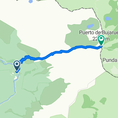
Route with great natural and landscape charm, we are at the very gates of the Ordesa National Park and this is noticeable. This is a half-day route with most of the ascent on an easy track and a descent on a moderately steep path over the Bujaruelo valley. It is highly recommended to do it in autumn due to the presence of beech and other deciduous trees in the area that give the mountain a lot of color at this time. We leave from the town of Torla and immediately take a marked path as PR towards the Ermita de San Miguel, thus avoiding the road. We overcome a vertical drop of just 70 m, but the path is hard and staggered, so we may have to walk a bit. At the Ermita de San Miguel we connect with the track that goes up to the repeater of Plana Cuasta, where we gain 800 m of vertical drop in a very calm way. Once up, it is worth going to the repeater that is located on a shoulder to the right of the pass of Plana, from here we will enjoy privileged views over the valley of Ordesa and the limestone walls of Mondarruego. On the way back to the pass, we will find a PR sign that introduces us to a path west that skirts the head of the ravine of las Comas almost without losing height until the next shoulder, the terrain is complicated and we have to walk in some sections. We go down the shoulder of Tasca looking for our way a bit and just before reaching a small pass, the PR introduces us to a beech forest as we lose height curve after curve. Further down we enter a pine area and travel along a fairly airy rocky ledge but safe above the Garganta de los Navarros from which we can see the valley of Bujaruelo. The path is quite accessible although there are some loose stones in sections, the gradual loss of height leads us to the road of Torla.
- -:--
- Duration
- 21.4 km
- Distance
- 1,123 m
- Ascent
- 1,123 m
- Descent
- ---
- Avg. speed
- ---
- Max. altitude

Continue with Bikemap
Use, edit, or download this cycling route
You would like to ride El Cebollar de Torla or customize it for your own trip? Here is what you can do with this Bikemap route:
Free features
- Save this route as favorite or in collections
- Copy & plan your own version of this route
- Sync your route with Garmin or Wahoo
Premium features
Free trial for 3 days, or one-time payment. More about Bikemap Premium.
- Navigate this route on iOS & Android
- Export a GPX / KML file of this route
- Create your custom printout (try it for free)
- Download this route for offline navigation
Discover more Premium features.
Get Bikemap PremiumFrom our community
Other popular routes starting in Broto
 Transpirenaica.Etapa11.Sarvisé-Senegüé
- Distance
- 54.9 km
- Ascent
- 1,131 m
- Descent
- 1,168 m
- Location
- Broto, Aragon, Spain
 Broto - Puértolas
- Distance
- 53.5 km
- Ascent
- 2,701 m
- Descent
- 3,725 m
- Location
- Broto, Aragon, Spain
 crestas vignemale
- Distance
- 35.3 km
- Ascent
- 2,972 m
- Descent
- 2,973 m
- Location
- Broto, Aragon, Spain
 TORLA-BIESCAS-SABIÑANIGO-FISCAL-BROTO-TORLA
- Distance
- 86.1 km
- Ascent
- 1,543 m
- Descent
- 1,544 m
- Location
- Broto, Aragon, Spain
 Wikiloc - Faja Racón, P. N. de Ordesa y Monte Perdido - Faja Racón, P. N. de Ordesa y Monte Perdido - Wikiloc
- Distance
- 9.2 km
- Ascent
- 1,440 m
- Descent
- 1,438 m
- Location
- Broto, Aragon, Spain
 Puerto de Bujaruelo
- Distance
- 4.8 km
- Ascent
- 934 m
- Descent
- 0 m
- Location
- Broto, Aragon, Spain
 day 6 Broto - Berdun
- Distance
- 89 km
- Ascent
- 873 m
- Descent
- 1,082 m
- Location
- Broto, Aragon, Spain
 24.07.2017 JS B2B 2017 V etapp Püreneedes
- Distance
- 69.4 km
- Ascent
- 1,993 m
- Descent
- 1,983 m
- Location
- Broto, Aragon, Spain
Open it in the app