
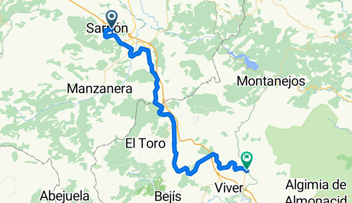
4.- Sarrión-Caudiel
A cycling route starting in Sarrión, Aragon, Spain.
Overview
About this route
- 3 h 13 min
- Duration
- 51.1 km
- Distance
- 438 m
- Ascent
- 791 m
- Descent
- 15.9 km/h
- Avg. speed
- 1,000 m
- Max. altitude

Route quality
Waytypes & surfaces along the route
Waytypes
Track
48.1 km
(94 %)
Quiet road
3 km
(6 %)
Surfaces
Paved
44 km
(86 %)
Paved (undefined)
44 km
(86 %)
Undefined
7.1 km
(14 %)
Continue with Bikemap
Use, edit, or download this cycling route
You would like to ride 4.- Sarrión-Caudiel or customize it for your own trip? Here is what you can do with this Bikemap route:
Free features
- Save this route as favorite or in collections
- Copy & plan your own version of this route
- Sync your route with Garmin or Wahoo
Premium features
Free trial for 3 days, or one-time payment. More about Bikemap Premium.
- Navigate this route on iOS & Android
- Export a GPX / KML file of this route
- Create your custom printout (try it for free)
- Download this route for offline navigation
Discover more Premium features.
Get Bikemap PremiumFrom our community
Other popular routes starting in Sarrión
 ESTACION DE MORA-SEGORBE (Maria de Luna)
- Distance
- 67 km
- Ascent
- 242 m
- Descent
- 809 m
- Location
- Sarrión, Aragon, Spain
 Venta del Aire-Titaguas-Venta del Aire.
- Distance
- 124.6 km
- Ascent
- 1,432 m
- Descent
- 1,428 m
- Location
- Sarrión, Aragon, Spain
 Aras de los Olmos importada de Strava
- Distance
- 122.7 km
- Ascent
- 1,435 m
- Descent
- 1,438 m
- Location
- Sarrión, Aragon, Spain
 Via verde ojos negros: Sarrión-Gilet
- Distance
- 98.7 km
- Ascent
- 128 m
- Descent
- 1,010 m
- Location
- Sarrión, Aragon, Spain
 4.- Sarrión-Caudiel
- Distance
- 51.1 km
- Ascent
- 438 m
- Descent
- 791 m
- Location
- Sarrión, Aragon, Spain
 Sarrión-Esquí Valdelinares-Sarrión
- Distance
- 108 km
- Ascent
- 1,617 m
- Descent
- 1,617 m
- Location
- Sarrión, Aragon, Spain
 Venta Aire-Valdelinares
- Distance
- 105.8 km
- Ascent
- 1,758 m
- Descent
- 1,758 m
- Location
- Sarrión, Aragon, Spain
 Vía verde Ojos Negros. 2 De Sarrión por río Palancia a Segorbe
- Distance
- 74.7 km
- Ascent
- 184 m
- Descent
- 774 m
- Location
- Sarrión, Aragon, Spain
Open it in the app