
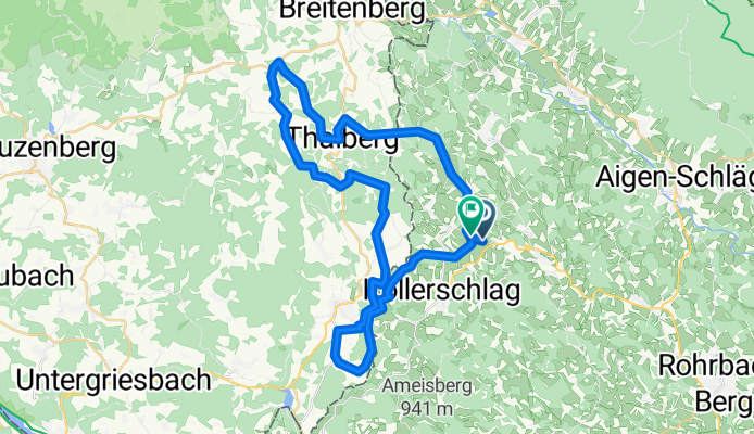
Vnb - Bachwirt - Fronau - Jagl - Kaiseralm - Kohlstatt
A cycling route starting in Nebelberg, Upper Austria, Austria.
Overview
About this route
- 2 h 56 min
- Duration
- 43.2 km
- Distance
- 956 m
- Ascent
- 952 m
- Descent
- 14.7 km/h
- Avg. speed
- 843 m
- Max. altitude

Route quality
Waytypes & surfaces along the route
Waytypes
Quiet road
29.2 km
(68 %)
Track
6.2 km
(14 %)
Surfaces
Paved
11.2 km
(26 %)
Unpaved
5.3 km
(12 %)
Asphalt
11.2 km
(26 %)
Gravel
3 km
(7 %)
Continue with Bikemap
Use, edit, or download this cycling route
You would like to ride Vnb - Bachwirt - Fronau - Jagl - Kaiseralm - Kohlstatt or customize it for your own trip? Here is what you can do with this Bikemap route:
Free features
- Save this route as favorite or in collections
- Copy & plan your own version of this route
- Sync your route with Garmin or Wahoo
Premium features
Free trial for 3 days, or one-time payment. More about Bikemap Premium.
- Navigate this route on iOS & Android
- Export a GPX / KML file of this route
- Create your custom printout (try it for free)
- Download this route for offline navigation
Discover more Premium features.
Get Bikemap PremiumFrom our community
Other popular routes starting in Nebelberg
 Fitnessrunde; Lengau-Haselbach-Blutwurzhütte-Kohlstatt
- Distance
- 44.1 km
- Ascent
- 587 m
- Descent
- 575 m
- Location
- Nebelberg, Upper Austria, Austria
 Tschechien Teil 2a
- Distance
- 70.4 km
- Ascent
- 829 m
- Descent
- 928 m
- Location
- Nebelberg, Upper Austria, Austria
 Monigottsöd 5, Wegscheid nach Monigottsöd 5, Wegscheid
- Distance
- 6.2 km
- Ascent
- 253 m
- Descent
- 268 m
- Location
- Nebelberg, Upper Austria, Austria
 Vnb - Rinnmühle - Unterthiergrub - Kriegwald - hoam
- Distance
- 29.7 km
- Ascent
- 814 m
- Descent
- 812 m
- Location
- Nebelberg, Upper Austria, Austria
 Transbayernwald von Nebelberg 001
- Distance
- 267.7 km
- Ascent
- 2,959 m
- Descent
- 3,264 m
- Location
- Nebelberg, Upper Austria, Austria
 Haselbachrunde erweitert
- Distance
- 34.9 km
- Ascent
- 877 m
- Descent
- 871 m
- Location
- Nebelberg, Upper Austria, Austria
 Druckerfranzlstein-Runde
- Distance
- 18.6 km
- Ascent
- 371 m
- Descent
- 367 m
- Location
- Nebelberg, Upper Austria, Austria
 Sarleinsbacher Runde
- Distance
- 30 km
- Ascent
- 589 m
- Descent
- 582 m
- Location
- Nebelberg, Upper Austria, Austria
Open it in the app