

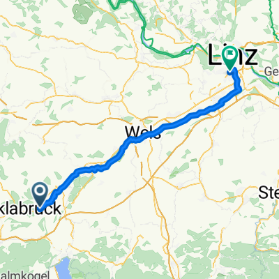
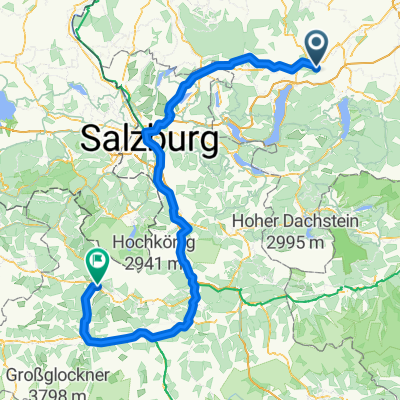
Unterach Mondsee Straßwalchen Regau
A cycling route starting in Attnang-Puchheim, Upper Austria, Austria.
Overview
About this route
- 5 h 34 min
- Duration
- 92.5 km
- Distance
- 1,201 m
- Ascent
- 1,123 m
- Descent
- 16.6 km/h
- Avg. speed
- 645 m
- Max. altitude

Route quality
Waytypes & surfaces along the route
Waytypes
Quiet road
42.5 km
(46 %)
Cycleway
15.7 km
(17 %)
Surfaces
Paved
58.2 km
(63 %)
Unpaved
0.9 km
(1 %)
Asphalt
57.3 km
(62 %)
Paved (undefined)
0.9 km
(1 %)
Continue with Bikemap
Use, edit, or download this cycling route
You would like to ride Unterach Mondsee Straßwalchen Regau or customize it for your own trip? Here is what you can do with this Bikemap route:
Free features
- Save this route as favorite or in collections
- Copy & plan your own version of this route
- Split it into stages to create a multi-day tour
- Sync your route with Garmin or Wahoo
Premium features
Free trial for 3 days, or one-time payment. More about Bikemap Premium.
- Navigate this route on iOS & Android
- Export a GPX / KML file of this route
- Create your custom printout (try it for free)
- Download this route for offline navigation
Discover more Premium features.
Get Bikemap PremiumFrom our community
Other popular routes starting in Attnang-Puchheim
 Schnelle Fahrt
- Distance
- 62.9 km
- Ascent
- 586 m
- Descent
- 585 m
- Location
- Attnang-Puchheim, Upper Austria, Austria
 Linz Traunuferweg
- Distance
- 67.9 km
- Ascent
- 69 m
- Descent
- 221 m
- Location
- Attnang-Puchheim, Upper Austria, Austria
 Daheim-Fisching-Daheim.gpx
- Distance
- 15.9 km
- Ascent
- 80 m
- Descent
- 77 m
- Location
- Attnang-Puchheim, Upper Austria, Austria
 MidlifeCycle 2025 - Day 10 - Ride 1 - Attnang-Puchheim to Ohlsdorf
- Distance
- 7.9 km
- Ascent
- 93 m
- Descent
- 81 m
- Location
- Attnang-Puchheim, Upper Austria, Austria
 Ostalpenlängsvorbei
- Distance
- 409.8 km
- Ascent
- 1,250 m
- Descent
- 960 m
- Location
- Attnang-Puchheim, Upper Austria, Austria
 Route nach Linz
- Distance
- 65 km
- Ascent
- 218 m
- Descent
- 363 m
- Location
- Attnang-Puchheim, Upper Austria, Austria
 Steinhübel Grünanger.gpx
- Distance
- 8.3 km
- Ascent
- 174 m
- Descent
- 176 m
- Location
- Attnang-Puchheim, Upper Austria, Austria
 Regau nach Florianiplatz
- Distance
- 198.9 km
- Ascent
- 2,702 m
- Descent
- 2,392 m
- Location
- Attnang-Puchheim, Upper Austria, Austria
Open it in the app