

Trainingsroute "Alb" 5.4.09
A cycling route starting in Deggingen, Baden-Wurttemberg, Germany.
Overview
About this route
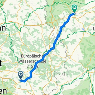
<p>Training on Alb-Extrem (28.06.09).</p>
<p>The whole route is on the road, although the part from B10 back to Deggingen (via Tomerdingen, Nellingen, Aufhausen) is on very lightly trafficked roads, making it well-suited for cycling.</p>
<p>From Deggingen to Geislingen, there is an option to ride on a bike path.</p>
<p>Geislingen towards Dornstadt is on B10, definitely not recommended on weekdays due to heavy traffic.</p>
<p>A significant climb (but long) is the Geislinger Steige. Then another 1-2 shorter ones at Urspring. Otherwise, 'it's hilly.'</p>
Translated, show original (German)- -:--
- Duration
- 64.9 km
- Distance
- 518 m
- Ascent
- 518 m
- Descent
- ---
- Avg. speed
- ---
- Max. altitude

Continue with Bikemap
Use, edit, or download this cycling route
You would like to ride Trainingsroute "Alb" 5.4.09 or customize it for your own trip? Here is what you can do with this Bikemap route:
Free features
- Save this route as favorite or in collections
- Copy & plan your own version of this route
- Sync your route with Garmin or Wahoo
Premium features
Free trial for 3 days, or one-time payment. More about Bikemap Premium.
- Navigate this route on iOS & Android
- Export a GPX / KML file of this route
- Create your custom printout (try it for free)
- Download this route for offline navigation
Discover more Premium features.
Get Bikemap PremiumFrom our community
Other popular routes starting in Deggingen
 Deggingen - Flugplatz Nortel
- Distance
- 13.3 km
- Ascent
- 231 m
- Descent
- 96 m
- Location
- Deggingen, Baden-Wurttemberg, Germany
 Trainingsroute "Alb" 5.4.09
- Distance
- 64.9 km
- Ascent
- 518 m
- Descent
- 518 m
- Location
- Deggingen, Baden-Wurttemberg, Germany
 Maxl_2014-05-22
- Distance
- 45.6 km
- Ascent
- 743 m
- Descent
- 743 m
- Location
- Deggingen, Baden-Wurttemberg, Germany
 zügigen rund
- Distance
- 31.2 km
- Ascent
- 885 m
- Descent
- 866 m
- Location
- Deggingen, Baden-Wurttemberg, Germany
 Reichenbach nach Ansbach
- Distance
- 126.7 km
- Ascent
- 725 m
- Descent
- 808 m
- Location
- Deggingen, Baden-Wurttemberg, Germany
 Klein aber fein mit tollem Ausblick
- Distance
- 17.6 km
- Ascent
- 570 m
- Descent
- 570 m
- Location
- Deggingen, Baden-Wurttemberg, Germany
 tdl
tdl- Distance
- 48.9 km
- Ascent
- 1,879 m
- Descent
- 1,905 m
- Location
- Deggingen, Baden-Wurttemberg, Germany
 Schwäb.Alb Galgenberg 20170518.gpx
- Distance
- 23.4 km
- Ascent
- 810 m
- Descent
- 806 m
- Location
- Deggingen, Baden-Wurttemberg, Germany
Open it in the app