

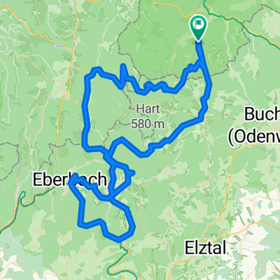
leichte Eistiegsrunde
A cycling route starting in Kirchzell, Bavaria, Germany.
Overview
About this route
- -:--
- Duration
- 48.7 km
- Distance
- 541 m
- Ascent
- 542 m
- Descent
- ---
- Avg. speed
- ---
- Max. altitude

Route quality
Waytypes & surfaces along the route
Waytypes
Road
18.5 km
(38 %)
Quiet road
11.2 km
(23 %)
Surfaces
Paved
37 km
(76 %)
Unpaved
1.5 km
(3 %)
Asphalt
34.6 km
(71 %)
Paved (undefined)
2.4 km
(5 %)
Continue with Bikemap
Use, edit, or download this cycling route
You would like to ride leichte Eistiegsrunde or customize it for your own trip? Here is what you can do with this Bikemap route:
Free features
- Save this route as favorite or in collections
- Copy & plan your own version of this route
- Sync your route with Garmin or Wahoo
Premium features
Free trial for 3 days, or one-time payment. More about Bikemap Premium.
- Navigate this route on iOS & Android
- Export a GPX / KML file of this route
- Create your custom printout (try it for free)
- Download this route for offline navigation
Discover more Premium features.
Get Bikemap PremiumFrom our community
Other popular routes starting in Kirchzell
 Kirchzell - Mudau - Gaimühle - Kirchzell
- Distance
- 59.4 km
- Ascent
- 1,317 m
- Descent
- 1,124 m
- Location
- Kirchzell, Bavaria, Germany
 Buch über Schwabenstein und Gleis 1 nach Buch
- Distance
- 23.1 km
- Ascent
- 400 m
- Descent
- 457 m
- Location
- Kirchzell, Bavaria, Germany
 Kirchzell - Breitenbuch - Würzberg - Wörth - Klingenberg - Mönchberg - Collenberg - Mil - Weilbach - Buch
- Distance
- 85.6 km
- Ascent
- 886 m
- Descent
- 886 m
- Location
- Kirchzell, Bavaria, Germany
 Kirchzell - Neckar - Kirchzell
- Distance
- 112.2 km
- Ascent
- 2,455 m
- Descent
- 2,278 m
- Location
- Kirchzell, Bavaria, Germany
 Miltenberg
- Distance
- 31.5 km
- Ascent
- 470 m
- Descent
- 459 m
- Location
- Kirchzell, Bavaria, Germany
 Große Mainroute Buch-Aschaffenburg-Würzburg-Buch
- Distance
- 226.1 km
- Ascent
- 1,115 m
- Descent
- 1,115 m
- Location
- Kirchzell, Bavaria, Germany
 Rundkurs Miltenberg
- Distance
- 84.1 km
- Ascent
- 1,146 m
- Descent
- 1,187 m
- Location
- Kirchzell, Bavaria, Germany
 tour 180417 amorbach miltenberg trailtour odenwald
- Distance
- 54.2 km
- Ascent
- 1,118 m
- Descent
- 1,118 m
- Location
- Kirchzell, Bavaria, Germany
Open it in the app