

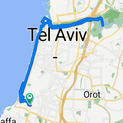
park Ariel Sharon
A cycling route starting in Jaffa, Tel Aviv, Israel.
Overview
About this route
- 2 h 13 min
- Duration
- 16.5 km
- Distance
- 210 m
- Ascent
- 228 m
- Descent
- 7.5 km/h
- Avg. speed
- 80 m
- Max. altitude

Continue with Bikemap
Use, edit, or download this cycling route
You would like to ride park Ariel Sharon or customize it for your own trip? Here is what you can do with this Bikemap route:
Free features
- Save this route as favorite or in collections
- Copy & plan your own version of this route
- Sync your route with Garmin or Wahoo
Premium features
Free trial for 3 days, or one-time payment. More about Bikemap Premium.
- Navigate this route on iOS & Android
- Export a GPX / KML file of this route
- Create your custom printout (try it for free)
- Download this route for offline navigation
Discover more Premium features.
Get Bikemap PremiumFrom our community
Other popular routes starting in Jaffa
 park Ariel Sharon
- Distance
- 16.5 km
- Ascent
- 210 m
- Descent
- 228 m
- Location
- Jaffa, Tel Aviv, Israel
 תל אביב הרצליה
- Distance
- 43.4 km
- Ascent
- 255 m
- Descent
- 255 m
- Location
- Jaffa, Tel Aviv, Israel
 מכללה לרכבת
- Distance
- 4.6 km
- Ascent
- 22 m
- Descent
- 17 m
- Location
- Jaffa, Tel Aviv, Israel
 outdoorladen neu
- Distance
- 14.2 km
- Ascent
- 92 m
- Descent
- 77 m
- Location
- Jaffa, Tel Aviv, Israel
 12.9.2024
- Distance
- 22.2 km
- Ascent
- 34 m
- Descent
- 54 m
- Location
- Jaffa, Tel Aviv, Israel
 Derech Yafo 50, Tel Aviv-Yafo to Nachlat Benyamin Street 66, Tel Aviv-Yafo
- Distance
- 4.1 km
- Ascent
- 18 m
- Descent
- 26 m
- Location
- Jaffa, Tel Aviv, Israel
 Aharon Chelouche Lane 21, Tel Aviv-Yafo to Herbert Samuel Pier 9, Tel Aviv-Yafo
- Distance
- 3 km
- Ascent
- 10 m
- Descent
- 22 m
- Location
- Jaffa, Tel Aviv, Israel
 הרב יצחק ידידיה פרנקל 4, תל אביב יפו to הרב יצחק ידידיה פרנקל 7, תל אביב יפו
- Distance
- 2.1 km
- Ascent
- 15 m
- Descent
- 14 m
- Location
- Jaffa, Tel Aviv, Israel
Open it in the app