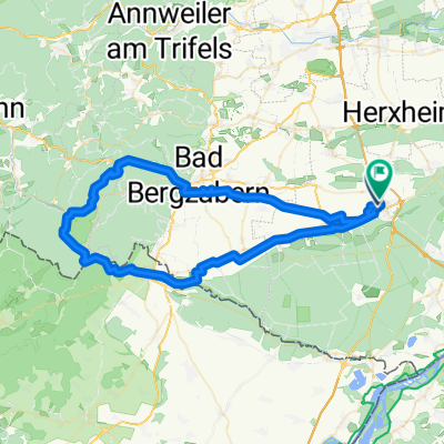
- 45.9 km
- 345 m
- 345 m
- Kandel, Rhineland-Palatinate, Germany
Vom Klingbach zum Kaiserbach
A cycling route starting in Kandel, Rhineland-Palatinate, Germany.
Overview
About this route
Parking lot: Kandel Industriestrasse: B 49.09970 L 8.18343 From Klingbach to Kaiserbach 24.02.2012 Minderslachen Steinweiler Mühlhofen Ingenheim Klingen Klingenmünster Münchweiler Silz Gossersweiler-Stein Völkersweiler Waldrohrbach Waldhambach Göcklingen Heuchelheim Appenhofen Billigheim Rohrbach Steinweiler Erlenbach Minderslachen
- -:--
- Duration
- 53.6 km
- Distance
- 257 m
- Ascent
- 258 m
- Descent
- ---
- Avg. speed
- ---
- Max. altitude
created this 13 years ago
Route quality
Waytypes & surfaces along the route
Waytypes
Track
30.6 km
(57 %)
Cycleway
7 km
(13 %)
Surfaces
Paved
42.3 km
(79 %)
Unpaved
6.4 km
(12 %)
Asphalt
29.5 km
(55 %)
Concrete
9.1 km
(17 %)
Route highlights
Points of interest along the route
Point of interest after 9.1 km
Bachweg
Point of interest after 15.9 km
www.klingenmuenster.de/
Point of interest after 16.9 km
www.burglandeck-pfalz.de/
Point of interest after 21.9 km
www.silz.de/
Point of interest after 25.1 km
www.gossersweiler-stein.de/
Point of interest after 27.2 km
Rastplatz, Quelle
Point of interest after 34.2 km
Naturschutzgebiet
Point of interest after 37.3 km
Altes Rathaus
Point of interest after 39.8 km
Fledermauskeller mit Schautafel
Point of interest after 40.7 km
Stadttor: www.billigheim-ingenheim.de/
Point of interest after 52 km
Flugmodelle: www.fmch.de/unser-verein/historisches/index.html
Point of interest after 52.1 km
Krankenhaus
Point of interest after 52.7 km
Wehrturm um 1500: www.kandel.de/
Point of interest after 52.8 km
Bogenschiesen
Continue with Bikemap
Use, edit, or download this cycling route
You would like to ride Vom Klingbach zum Kaiserbach or customize it for your own trip? Here is what you can do with this Bikemap route:
Free features
- Save this route as favorite or in collections
- Copy & plan your own version of this route
- Sync your route with Garmin or Wahoo
Premium features
Free trial for 3 days, or one-time payment. More about Bikemap Premium.
- Navigate this route on iOS & Android
- Export a GPX / KML file of this route
- Create your custom printout (try it for free)
- Download this route for offline navigation
Discover more Premium features.
Get Bikemap PremiumFrom our community
Other popular routes starting in Kandel
- Dörrenbach
- Weinberge
- 45.5 km
- 185 m
- 184 m
- Kandel, Rhineland-Palatinate, Germany
- Firstweg Kandel
- 43 km
- 199 m
- 198 m
- Kandel, Rhineland-Palatinate, Germany
- um Minderslachen
- 11.4 km
- 28 m
- 29 m
- Kandel, Rhineland-Palatinate, Germany
- Krummer Ellenbogen
- 66 km
- 899 m
- 899 m
- Kandel, Rhineland-Palatinate, Germany
- Walsheimer Hütte
- 77.2 km
- 529 m
- 529 m
- Kandel, Rhineland-Palatinate, Germany
- Vom Klingbach zum Kaiserbach
- 53.6 km
- 257 m
- 258 m
- Kandel, Rhineland-Palatinate, Germany
- Von Kandel bis Maikammer
- 61.2 km
- 705 m
- 661 m
- Kandel, Rhineland-Palatinate, Germany
Open it in the app


