

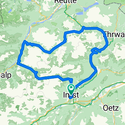
Hahntennjoch - Lechtal - Namlos - Fernpass
A cycling route starting in Imst, Tyrol, Austria.
Overview
About this route
Anspruchsvolle Tagestour durch die faszinierende Alpenwelt. Die Tour sollte möglichst unter der Woche frühmorgens begonnen werden, um den Motorradverkehr am Hahntennjoch zu vermeiden. Der Fernpass kann auch auf der Via Claudia überquert werden.
- -:--
- Duration
- 101.1 km
- Distance
- 1,833 m
- Ascent
- 1,833 m
- Descent
- ---
- Avg. speed
- ---
- Avg. speed

Route quality
Waytypes & surfaces along the route
Waytypes
Busy road
76.4 km
(76 %)
Quiet road
11.7 km
(12 %)
Surfaces
Paved
93.3 km
(92 %)
Unpaved
4 km
(4 %)
Asphalt
92.9 km
(92 %)
Gravel
2.7 km
(3 %)
Continue with Bikemap
Use, edit, or download this cycling route
You would like to ride Hahntennjoch - Lechtal - Namlos - Fernpass or customize it for your own trip? Here is what you can do with this Bikemap route:
Free features
- Save this route as favorite or in collections
- Copy & plan your own version of this route
- Sync your route with Garmin or Wahoo
Premium features
Free trial for 3 days, or one-time payment. More about Bikemap Premium.
- Navigate this route on iOS & Android
- Export a GPX / KML file of this route
- Create your custom printout (try it for free)
- Download this route for offline navigation
Discover more Premium features.
Get Bikemap PremiumFrom our community
Other popular routes starting in Imst
 Imst - Dorf Tirol via Timmelsjoch
- Distance
- 119.4 km
- Ascent
- 2,076 m
- Descent
- 2,206 m
- Location
- Imst, Tyrol, Austria
 TOUR-Transalp 2011 - 2. Etappe
- Distance
- 146.9 km
- Ascent
- 2,735 m
- Descent
- 2,157 m
- Location
- Imst, Tyrol, Austria
 Fabrikstraße 34, Gemeinde Imst do Kronburg 105, Zammerberg
- Distance
- 13.7 km
- Ascent
- 321 m
- Descent
- 110 m
- Location
- Imst, Tyrol, Austria
 Etappe 2 | Imst bis Nauders
- Distance
- 73 km
- Ascent
- 2,187 m
- Descent
- 1,643 m
- Location
- Imst, Tyrol, Austria
 Kühtai
- Distance
- 101.2 km
- Ascent
- 1,672 m
- Descent
- 1,672 m
- Location
- Imst, Tyrol, Austria
 Jeantex Tour Transalp 2007 2. Etappe
- Distance
- 148 km
- Ascent
- 2,499 m
- Descent
- 1,928 m
- Location
- Imst, Tyrol, Austria
 Ischgl/Hahntennjoch/Nassenreith/Landeck/Ischgl
- Distance
- 101 km
- Ascent
- 2,068 m
- Descent
- 2,072 m
- Location
- Imst, Tyrol, Austria
 2010 imst - weer 7.07.10
- Distance
- 89.2 km
- Ascent
- 128 m
- Descent
- 313 m
- Location
- Imst, Tyrol, Austria
Open it in the app