Časovka Dobrá-Pazderná
- 6.4 km
- 59 m
- 50 m
- Staré Město, Moravskoslezský kraj, Czechia
The time trial is the next race in the SPAC series 2012
Organizer - Racing Olešná Frýdek-Místek
Date - 13.5.2012
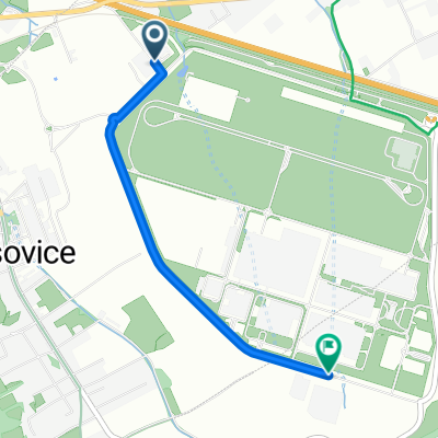
Start - in front of the IZS Building in Nošovice
Finish - at the Restaurant Kohurka in Vyšních Lhotách
Length - 17 km
Route description - after the start, the racers will turn right after about 200 m onto the bypass road around the Hyundai plant. From this circuit, after about 5 km, they will turn right onto the overpass over the highway. After crossing, the route will join the district road F. Místek-Český Těšín and turn right. There will follow about 700 m of flat road and then a descent into Vojkovice. In this village, the route will turn sharply right onto the road towards Dobratice. For about 1.5 km on this road, the route will slightly ascend beside the restaurant U Koníčka until it reaches the underpass under the highway and railway, where the racers will face approximately 3.5 km of climbing through the village of Dobratice interrupted by a steep climb at the end of the village and another steep ascent to the top of the climb at the restaurant Harenda. A less than one kilometer flat section will follow to the former school in Višňovka, where the route turns into a descent into V. Lhotách, interrupted by a brief "bump" at the water treatment plant. At the end of the descent, at about 14.5 km, the route will turn around at the turnaround in V. Lhotách, and the racers will have to tackle the ascent back to Višňovka. Until this moment, the route is on quality asphalt. However, near Višňovka, the racers will sharply turn right, and they will face the final 600 m climb on poor-quality road to the finish at Kohutka.
Infrastructure - we advise racers and their companions that parking vehicles along the road in the start area will not be possible as last year. Parking is possible in the large public parking lot in front of the "office building" Hyundai about 2.5 km from the start (see map). There are no toilets available in the parking lot or in the start area. However, everyone will find the well-established facilities of the Kohutka restaurant at the finish, with all social amenities and two parking lots.
Road
10.4 km61 %Quiet road
4.4 km26 %Paved
1.9 km(11 %)Asphalt
1.9 km11 %Undefined
15.2 km89 %
Start před budovou IZS v Nošovicích.

Kruhový objezd č.1.

Areál ČEZ.

Pivovar Radegast v Nošovicích.

Parkoviště před office building.

Kruhový objezd č.2.

Nadjezd přes dálnici.

Restaurace Hotel Nošovice.

Výjezd na okresku F.Místek - Č.Těšín.

Sjezd do Vojkovic.

Odbočka do Dobratic ve Vojkovicích.

Restaurace U Koníčka.

Podjezd v Dobraticích.

Restaurace Obecník v Dobraticích.

Stoupání za Dobraticemi.

Stoupání k Harendě.

Restaurace Harenda.

Višňovka.

Sjezd do Vyšních Lhot.

Úpravna vody ve Vyšních Lhotách.

Obrátka ve Vyšních Lhotách.

Stoupání na Kohutku.

Restaurace Kohutka.Zázemí,parkoviště.

Cíl na Kohutce.

Parkoviště na Kamenitém.
Free trial for 3 days, or one-time payment. More about Bikemap Premium.
Discover more Premium features.
Get Bikemap PremiumOpen it in the app