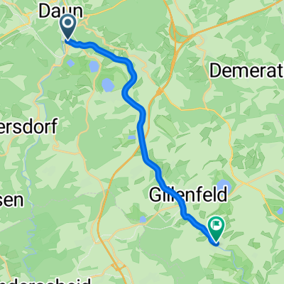
25 Daun Wittlich Mosel Maare Radweg
A cycling route starting in Daun, Rhineland-Palatinate, Germany.
Overview
About this route
<p>Super cycle path !!</p>
<p>Access to Daun with DB (to Gerolstein) and bus, cyclist bus line 500, then follow the signs from Daun station.... Tunnels, fields, meadows, lakes... great cycle path.</p>
<p>
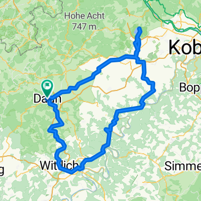
Return with DB from Wittlich Wengerohr (Wittlich Hbf)</p>
<p> </p>
Translated, show original (German)- -:--
- Duration
- 42.3 km
- Distance
- 191 m
- Ascent
- 437 m
- Descent
- ---
- Avg. speed
- ---
- Max. altitude
Route highlights
Points of interest along the route
Point of interest after 0 km
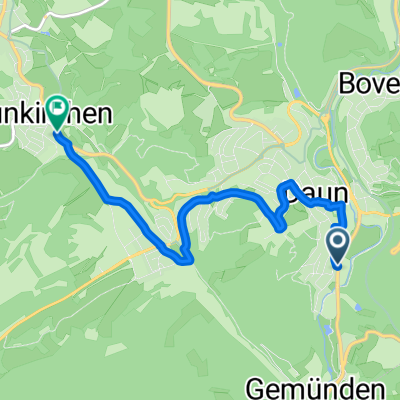
Start am Bahnhof Daun
Photo after 0.4 km
Blick vom Viadukt auf Daun
Photo after 2.8 km
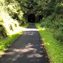
Tunnelportal "Großes Schlitzohr"
Photo after 11.3 km
Lava Bombe
Photo after 13.5 km
Holzmaar
Photo after 31.1 km
Blick über Eifelhöhen
Photo after 39.8 km
In Wittlich
Continue with Bikemap
Use, edit, or download this cycling route
You would like to ride 25 Daun Wittlich Mosel Maare Radweg or customize it for your own trip? Here is what you can do with this Bikemap route:
Free features
- Save this route as favorite or in collections
- Copy & plan your own version of this route
- Sync your route with Garmin or Wahoo
Premium features
Free trial for 3 days, or one-time payment. More about Bikemap Premium.
- Navigate this route on iOS & Android
- Export a GPX / KML file of this route
- Create your custom printout (try it for free)
- Download this route for offline navigation
Discover more Premium features.
Get Bikemap PremiumFrom our community
Other popular routes starting in Daun
- Maare - Mosel
- Distance
- 59.8 km
- Ascent
- 254 m
- Descent
- 497 m
- Location
- Daun, Rhineland-Palatinate, Germany
- 4 Krater Tour
- Distance
- 55.4 km
- Ascent
- 887 m
- Descent
- 874 m
- Location
- Daun, Rhineland-Palatinate, Germany
- Dauner Runde 1. Teil
- Distance
- 75.1 km
- Ascent
- 886 m
- Descent
- 877 m
- Location
- Daun, Rhineland-Palatinate, Germany
- L3110 - détour vers Dronke-Turm
- Distance
- 3.3 km
- Ascent
- 142 m
- Descent
- 142 m
- Location
- Daun, Rhineland-Palatinate, Germany
- MOSEL-Radweg 5Tag Sa.19.09.15.
- Distance
- 57.6 km
- Ascent
- 226 m
- Descent
- 514 m
- Location
- Daun, Rhineland-Palatinate, Germany
- Maare-Mosel Radweg
- Distance
- 57.8 km
- Ascent
- 197 m
- Descent
- 469 m
- Location
- Daun, Rhineland-Palatinate, Germany
- Tour 51,6km, Daun - Niederstadtfeld - Manderscheid - Brockscheid - Gillenfeld - Schalkenmehren - Daun
- Distance
- 51.6 km
- Ascent
- 889 m
- Descent
- 883 m
- Location
- Daun, Rhineland-Palatinate, Germany
- Pützborn-Schalkenmehren-Winkel-BadBertrich-Alf-Reil-Strotzbüsch-Gillenfeld-Gemünden-Pützborn
- Distance
- 108.1 km
- Ascent
- 940 m
- Descent
- 931 m
- Location
- Daun, Rhineland-Palatinate, Germany
Open it in the app