Krummer Ellenbogen
- 66 km
- 899 m
- 899 m
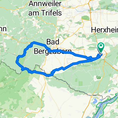
- Kandel, Rhineland-Palatinate, Germany
A cycling route starting in Kandel, Rhineland-Palatinate, Germany.
Overview
Parking: Kandel Industriestrasse B 49.09970 L 8.18343 Up towards Bergzabern to the three oaks, then down to Dörrenbach (a small medieval town, Town Hall!) then continue eastward on the ridge path with beautiful views, through vineyards back to the starting point.
created this 13 years ago
Route quality
Track
22.5 km
(49 %)
Quiet road
5.5 km
(12 %)
Paved
34.5 km
(75 %)
Unpaved
6.4 km
(14 %)
Asphalt
31.2 km
(68 %)
Gravel
4.6 km
(10 %)
Route highlights
Nachtwaechterhaus Rathaus Winzerhoefe http://www.meinestadt.de/winden-pfalz/bilder/detail?id=8162
Schloss http://www.bad-bergzabern.de/
www.kandel.de/
Continue with Bikemap
You would like to ride Dörrenbach or customize it for your own trip? Here is what you can do with this Bikemap route:
Free trial for 3 days, or one-time payment. More about Bikemap Premium.
Discover more Premium features.
Get Bikemap PremiumFrom our community
Open it in the app