
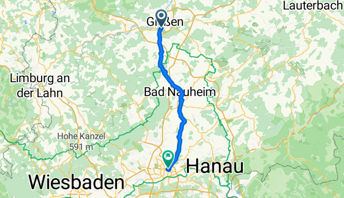
Gi -Ffm
A cycling route starting in Heuchelheim, Hesse, Germany.
Overview
About this route
- -:--
- Duration
- 58.9 km
- Distance
- 281 m
- Ascent
- 315 m
- Descent
- ---
- Avg. speed
- ---
- Max. altitude
Continue with Bikemap
Use, edit, or download this cycling route
You would like to ride Gi -Ffm or customize it for your own trip? Here is what you can do with this Bikemap route:
Free features
- Save this route as favorite or in collections
- Copy & plan your own version of this route
- Sync your route with Garmin or Wahoo
Premium features
Free trial for 3 days, or one-time payment. More about Bikemap Premium.
- Navigate this route on iOS & Android
- Export a GPX / KML file of this route
- Create your custom printout (try it for free)
- Download this route for offline navigation
Discover more Premium features.
Get Bikemap PremiumFrom our community
Other popular routes starting in Heuchelheim
 Trail im Krofdorfer Forst
- Distance
- 19.8 km
- Ascent
- 263 m
- Descent
- 290 m
- Location
- Heuchelheim, Hesse, Germany
 Gr. Buseck - Duensberg - Gr. Buseck
- Distance
- 51.1 km
- Ascent
- 363 m
- Descent
- 593 m
- Location
- Heuchelheim, Hesse, Germany
 Lahntal Heuchelheim Wetzlar
- Distance
- 21.6 km
- Ascent
- 105 m
- Descent
- 106 m
- Location
- Heuchelheim, Hesse, Germany
 Rodheimer Straße - Waldhäuser Straße
- Distance
- 43 km
- Ascent
- 157 m
- Descent
- 124 m
- Location
- Heuchelheim, Hesse, Germany
 Zur Aartalsperre
- Distance
- 62.3 km
- Ascent
- 549 m
- Descent
- 550 m
- Location
- Heuchelheim, Hesse, Germany
 Ins "Allgäu"
- Distance
- 39.5 km
- Ascent
- 582 m
- Descent
- 580 m
- Location
- Heuchelheim, Hesse, Germany
 Gießen-Süd Oberwetz-Gießen-Süd
- Distance
- 57.4 km
- Ascent
- 447 m
- Descent
- 446 m
- Location
- Heuchelheim, Hesse, Germany
 Lahn Taunus Wetterau
- Distance
- 179.9 km
- Ascent
- 586 m
- Descent
- 586 m
- Location
- Heuchelheim, Hesse, Germany
Open it in the app