

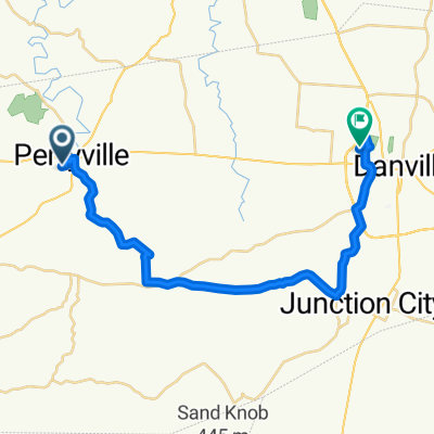
Route to Daisy Street 182, Harrodsburg
A cycling route starting in Junction City, Kentucky, United States.
Overview
About this route
- 44 min
- Duration
- 28 km
- Distance
- 127 m
- Ascent
- 120 m
- Descent
- 38.2 km/h
- Avg. speed
- 301 m
- Max. altitude

Route quality
Waytypes & surfaces along the route
Waytypes
Road
10.4 km
(37 %)
Cycleway
9.2 km
(33 %)
Continue with Bikemap
Use, edit, or download this cycling route
You would like to ride Route to Daisy Street 182, Harrodsburg or customize it for your own trip? Here is what you can do with this Bikemap route:
Free features
- Save this route as favorite or in collections
- Copy & plan your own version of this route
- Sync your route with Garmin or Wahoo
Premium features
Free trial for 3 days, or one-time payment. More about Bikemap Premium.
- Navigate this route on iOS & Android
- Export a GPX / KML file of this route
- Create your custom printout (try it for free)
- Download this route for offline navigation
Discover more Premium features.
Get Bikemap PremiumFrom our community
Other popular routes starting in Junction City
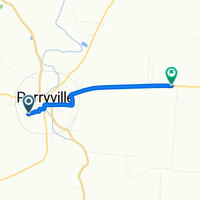
 West 5th Street 400 10, Perryville to East 2nd Street 303, Perryville
- Distance
- 1 km
- Ascent
- 24 m
- Descent
- 24 m
- Location
- Junction City, Kentucky, United States
 West 5th Street 400 10, Perryville to Louisville Road 1505, Harrodsburg
- Distance
- 31.2 km
- Ascent
- 159 m
- Descent
- 135 m
- Location
- Junction City, Kentucky, United States
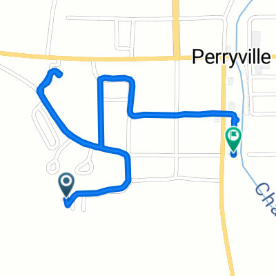
 East 2nd Street 301, Perryville to West 5th Street 400 10, Perryville
- Distance
- 2.6 km
- Ascent
- 43 m
- Descent
- 7 m
- Location
- Junction City, Kentucky, United States
 Route to Daisy Street 182, Harrodsburg
- Distance
- 28 km
- Ascent
- 127 m
- Descent
- 120 m
- Location
- Junction City, Kentucky, United States
 West 5th Street 400 13, Perryville to North Danville Bypass 550
- Distance
- 28.7 km
- Ascent
- 168 m
- Descent
- 118 m
- Location
- Junction City, Kentucky, United States
 West 5th Street 400 11, Perryville to Perryville Road 8010, Danville
- Distance
- 4.1 km
- Ascent
- 60 m
- Descent
- 25 m
- Location
- Junction City, Kentucky, United States
 West 5th Street 400 20, Perryville to South Buell Street 344, Perryville
- Distance
- 1.7 km
- Ascent
- 28 m
- Descent
- 28 m
- Location
- Junction City, Kentucky, United States
 West 5th Street 400 9, Perryville to Ash Brook Lane 149, Harrodsburg
- Distance
- 32.1 km
- Ascent
- 179 m
- Descent
- 162 m
- Location
- Junction City, Kentucky, United States
Open it in the app