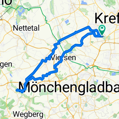
R 95 Tönisvorst
A cycling route starting in Tönisvorst, North Rhine-Westphalia, Germany.
Overview
About this route
Beautiful ride on the left bank of the Rhine. It is suitable for both beginners and advanced cyclists as a training ride.
- -:--
- Duration
- 75.3 km
- Distance
- 178 m
- Ascent
- 178 m
- Descent
- ---
- Avg. speed
- 83 m
- Max. altitude
Route quality
Waytypes & surfaces along the route
Waytypes
Quiet road
42.2 km
(56 %)
Road
11.3 km
(15 %)
Surfaces
Paved
70.8 km
(94 %)
Unpaved
0.8 km
(1 %)
Asphalt
70 km
(93 %)
Paved (undefined)
0.8 km
(1 %)
Continue with Bikemap
Use, edit, or download this cycling route
You would like to ride R 95 Tönisvorst or customize it for your own trip? Here is what you can do with this Bikemap route:
Free features
- Save this route as favorite or in collections
- Copy & plan your own version of this route
- Sync your route with Garmin or Wahoo
Premium features
Free trial for 3 days, or one-time payment. More about Bikemap Premium.
- Navigate this route on iOS & Android
- Export a GPX / KML file of this route
- Create your custom printout (try it for free)
- Download this route for offline navigation
Discover more Premium features.
Get Bikemap PremiumFrom our community
Other popular routes starting in Tönisvorst
Rund um Hüls- Distance
- 24 km
- Ascent
- 53 m
- Descent
- 53 m
- Location
- Tönisvorst, North Rhine-Westphalia, Germany
Zur Dienststelle- Distance
- 14.4 km
- Ascent
- 10 m
- Descent
- 12 m
- Location
- Tönisvorst, North Rhine-Westphalia, Germany
Kleiner und Großer De Wittsee – Bahntrasse Runde von Forsthaus- Distance
- 64.3 km
- Ascent
- 122 m
- Descent
- 125 m
- Location
- Tönisvorst, North Rhine-Westphalia, Germany
Rund um Krefeld mit Biergarten Dujardin- Distance
- 57.2 km
- Ascent
- 47 m
- Descent
- 47 m
- Location
- Tönisvorst, North Rhine-Westphalia, Germany
Rundweg bis Oedt/Niers - ClörathAnrath - Kehn/Tack- Distance
- 27.7 km
- Ascent
- 34 m
- Descent
- 36 m
- Location
- Tönisvorst, North Rhine-Westphalia, Germany
Radmarathon durch KR und VIE- Distance
- 50.2 km
- Ascent
- 34 m
- Descent
- 35 m
- Location
- Tönisvorst, North Rhine-Westphalia, Germany
Hülser Berg- Distance
- 27.5 km
- Ascent
- 59 m
- Descent
- 59 m
- Location
- Tönisvorst, North Rhine-Westphalia, Germany
HHS-Stautenhof-Höfkes-HHS- Distance
- 33.4 km
- Ascent
- 24 m
- Descent
- 26 m
- Location
- Tönisvorst, North Rhine-Westphalia, Germany
Open it in the app


