

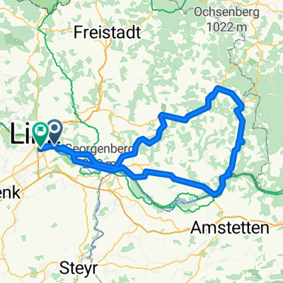
Falterweg 62a, Linz nach Falterweg 62, Linz
A cycling route starting in Steyregg, Upper Austria, Austria.
Overview
About this route
- 5 h 5 min
- Duration
- 89.7 km
- Distance
- 508 m
- Ascent
- 508 m
- Descent
- 17.6 km/h
- Avg. speed
- 366 m
- Avg. speed
Route quality
Waytypes & surfaces along the route
Waytypes
Quiet road
30.6 km
(34 %)
Track
18 km
(20 %)
Surfaces
Paved
69.9 km
(78 %)
Unpaved
3.5 km
(4 %)
Asphalt
68.5 km
(76 %)
Ground
2.1 km
(2 %)
Continue with Bikemap
Use, edit, or download this cycling route
You would like to ride Falterweg 62a, Linz nach Falterweg 62, Linz or customize it for your own trip? Here is what you can do with this Bikemap route:
Free features
- Save this route as favorite or in collections
- Copy & plan your own version of this route
- Split it into stages to create a multi-day tour
- Sync your route with Garmin or Wahoo
Premium features
Free trial for 3 days, or one-time payment. More about Bikemap Premium.
- Navigate this route on iOS & Android
- Export a GPX / KML file of this route
- Create your custom printout (try it for free)
- Download this route for offline navigation
Discover more Premium features.
Get Bikemap PremiumFrom our community
Other popular routes starting in Steyregg
 20190111 Spaziergang mit Krone
- Distance
- 10.3 km
- Ascent
- 282 m
- Descent
- 281 m
- Location
- Steyregg, Upper Austria, Austria
 Linz-Königswiesen-Grein-Linz
- Distance
- 151.6 km
- Ascent
- 935 m
- Descent
- 923 m
- Location
- Steyregg, Upper Austria, Austria
 MTB Runde 55km - Satzing - Pürach - Götzelsdorf - Holzwinden - Lachstadt - Pfenningberg - Plesching - Linz-Urfahr - Lichtenberg - GIS Warte - Lichtenberg - Linz
- Distance
- 55.7 km
- Ascent
- 1,295 m
- Descent
- 1,297 m
- Location
- Steyregg, Upper Austria, Austria
 Mountainbike SolarCity - GIS (Giselawarte)
- Distance
- 27.3 km
- Ascent
- 778 m
- Descent
- 101 m
- Location
- Steyregg, Upper Austria, Austria
 erste Etappe Ly und jo
- Distance
- 75.9 km
- Ascent
- 386 m
- Descent
- 136 m
- Location
- Steyregg, Upper Austria, Austria
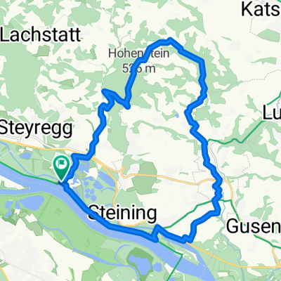 Hohenstein
- Distance
- 21.5 km
- Ascent
- 306 m
- Descent
- 308 m
- Location
- Steyregg, Upper Austria, Austria
 Nette Abendrunde
- Distance
- 39.2 km
- Ascent
- 472 m
- Descent
- 465 m
- Location
- Steyregg, Upper Austria, Austria
 Linz-Gramastetten-Kirchaschlag-Goli-Linz
- Distance
- 70.8 km
- Ascent
- 1,424 m
- Descent
- 1,424 m
- Location
- Steyregg, Upper Austria, Austria
Open it in the app