
Watzkerunde 1. März Pegenau Kobitzsch Kauferbach Steinbach
A cycling route starting in Dresden, Saxony, Germany.
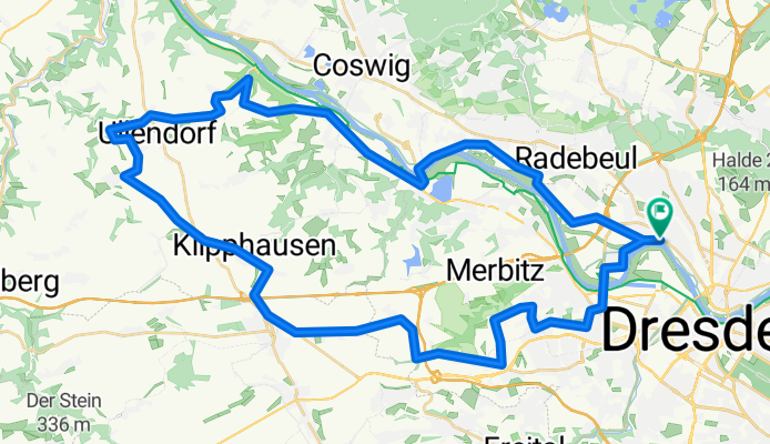
Overview
About this route
Watzke-Vorglühen 1. März 2012
- -:--
- Duration
- 52.9 km
- Distance
- 336 m
- Ascent
- 336 m
- Descent
- ---
- Avg. speed
- ---
- Max. altitude

Route quality
Waytypes & surfaces along the route
Waytypes
Quiet road
27.2 km
(51 %)
Road
12 km
(23 %)
Surfaces
Paved
47.6 km
(90 %)
Unpaved
0.1 km
(<1 %)
Asphalt
45.8 km
(87 %)
Paving stones
1.7 km
(3 %)
Continue with Bikemap
Use, edit, or download this cycling route
You would like to ride Watzkerunde 1. März Pegenau Kobitzsch Kauferbach Steinbach or customize it for your own trip? Here is what you can do with this Bikemap route:
Free features
- Save this route as favorite or in collections
- Copy & plan your own version of this route
- Sync your route with Garmin or Wahoo
Premium features
Free trial for 3 days, or one-time payment. More about Bikemap Premium.
- Navigate this route on iOS & Android
- Export a GPX / KML file of this route
- Create your custom printout (try it for free)
- Download this route for offline navigation
Discover more Premium features.
Get Bikemap PremiumFrom our community
Other popular routes starting in Dresden
 Pre Velorace Trainingsausfahrt 2015 Einsteiger
- Distance
- 44.6 km
- Ascent
- 222 m
- Descent
- 222 m
- Location
- Dresden, Saxony, Germany
 Dresden - Glashütte - Bahratal
- Distance
- 90.4 km
- Ascent
- 1,112 m
- Descent
- 1,142 m
- Location
- Dresden, Saxony, Germany
 Dresden - Prag
- Distance
- 217.2 km
- Ascent
- 388 m
- Descent
- 303 m
- Location
- Dresden, Saxony, Germany
 Dresden - Stolpen -Rathen
- Distance
- 54 km
- Ascent
- 447 m
- Descent
- 446 m
- Location
- Dresden, Saxony, Germany
 Schmorsdorfer Höhenrunde
- Distance
- 49.8 km
- Ascent
- 510 m
- Descent
- 488 m
- Location
- Dresden, Saxony, Germany
 cielab.org - Dresden - Bahratal - Mückentürmchen
- Distance
- 130 km
- Ascent
- 1,524 m
- Descent
- 1,516 m
- Location
- Dresden, Saxony, Germany
 Rennradrunde um den Tharandter Wald
- Distance
- 78.9 km
- Ascent
- 934 m
- Descent
- 850 m
- Location
- Dresden, Saxony, Germany
 Müglitztal - Königstein - Breitenau
- Distance
- 156 km
- Ascent
- 2,539 m
- Descent
- 2,398 m
- Location
- Dresden, Saxony, Germany
Open it in the app