

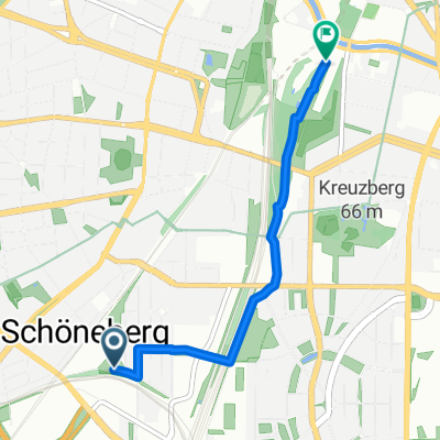
Spreewiesenrunde
A cycling route starting in Berlin Schöneberg, State of Berlin, Germany.
Overview
About this route
- -:--
- Duration
- 107.1 km
- Distance
- 283 m
- Ascent
- 293 m
- Descent
- ---
- Avg. speed
- 59 m
- Max. altitude
Route quality
Waytypes & surfaces along the route
Waytypes
Road
24.6 km
(23 %)
Quiet road
21.4 km
(20 %)
Surfaces
Paved
81.4 km
(76 %)
Unpaved
9.6 km
(9 %)
Asphalt
80.3 km
(75 %)
Ground
6.4 km
(6 %)
Continue with Bikemap
Use, edit, or download this cycling route
You would like to ride Spreewiesenrunde or customize it for your own trip? Here is what you can do with this Bikemap route:
Free features
- Save this route as favorite or in collections
- Copy & plan your own version of this route
- Split it into stages to create a multi-day tour
- Sync your route with Garmin or Wahoo
Premium features
Free trial for 3 days, or one-time payment. More about Bikemap Premium.
- Navigate this route on iOS & Android
- Export a GPX / KML file of this route
- Create your custom printout (try it for free)
- Download this route for offline navigation
Discover more Premium features.
Get Bikemap PremiumFrom our community
Other popular routes starting in Berlin Schöneberg
 Verbesserte Tr.Runde im Südwesten
- Distance
- 114.1 km
- Ascent
- 215 m
- Descent
- 219 m
- Location
- Berlin Schöneberg, State of Berlin, Germany
 CC Ride #2
- Distance
- 3 km
- Ascent
- 11 m
- Descent
- 17 m
- Location
- Berlin Schöneberg, State of Berlin, Germany
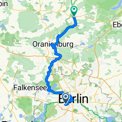 Dag 1 Berlin- Oranienburg
- Distance
- 78.2 km
- Ascent
- 251 m
- Descent
- 252 m
- Location
- Berlin Schöneberg, State of Berlin, Germany
 Kurze morgendliche Tainingsrunde für die Woche
- Distance
- 58.4 km
- Ascent
- 78 m
- Descent
- 87 m
- Location
- Berlin Schöneberg, State of Berlin, Germany
 Spreewiesenrunde
- Distance
- 107.1 km
- Ascent
- 283 m
- Descent
- 293 m
- Location
- Berlin Schöneberg, State of Berlin, Germany
 Trainingsrunde Thyrow
- Distance
- 83.7 km
- Ascent
- 106 m
- Descent
- 106 m
- Location
- Berlin Schöneberg, State of Berlin, Germany
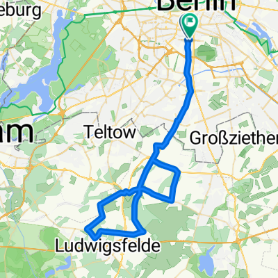
 Beelitz
- Distance
- 97.5 km
- Ascent
- 153 m
- Descent
- 152 m
- Location
- Berlin Schöneberg, State of Berlin, Germany
 Grunewald lap
- Distance
- 36.7 km
- Ascent
- 146 m
- Descent
- 142 m
- Location
- Berlin Schöneberg, State of Berlin, Germany
Open it in the app