
Mödlereuth-Trojmezi
A cycling route starting in Töpen, Bavaria, Germany.
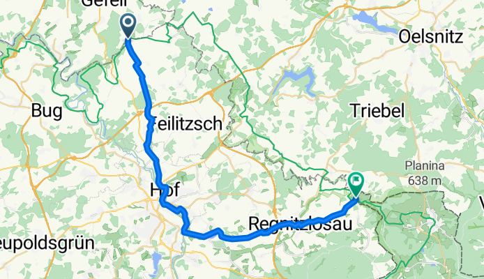
Overview
About this route
- -:--
- Duration
- 29.6 km
- Distance
- 340 m
- Ascent
- 336 m
- Descent
- ---
- Avg. speed
- ---
- Max. altitude

Route quality
Waytypes & surfaces along the route
Waytypes
Road
12.6 km
(43 %)
Quiet road
11.4 km
(38 %)
Surfaces
Paved
6.7 km
(23 %)
Unpaved
1 km
(3 %)
Asphalt
6 km
(20 %)
Gravel
0.7 km
(2 %)
Route highlights
Points of interest along the route
Point of interest after 10.9 km
Altstadt - Stare mesto
Point of interest after 12 km
Bierpalast
Point of interest after 12.3 km
Koupaliste
Point of interest after 12.9 km
Brauereimuseum - Pivovarske museum
Continue with Bikemap
Use, edit, or download this cycling route
You would like to ride Mödlereuth-Trojmezi or customize it for your own trip? Here is what you can do with this Bikemap route:
Free features
- Save this route as favorite or in collections
- Copy & plan your own version of this route
- Sync your route with Garmin or Wahoo
Premium features
Free trial for 3 days, or one-time payment. More about Bikemap Premium.
- Navigate this route on iOS & Android
- Export a GPX / KML file of this route
- Create your custom printout (try it for free)
- Download this route for offline navigation
Discover more Premium features.
Get Bikemap PremiumFrom our community
Other popular routes starting in Töpen
 Saale 2 (Hirschberg-Ziegenrück)
- Distance
- 65.8 km
- Ascent
- 720 m
- Descent
- 839 m
- Location
- Töpen, Bavaria, Germany
 Hof-Mödlareuth
- Distance
- 13.4 km
- Ascent
- 233 m
- Descent
- 251 m
- Location
- Töpen, Bavaria, Germany
 grünes band
- Distance
- 79.2 km
- Ascent
- 946 m
- Descent
- 917 m
- Location
- Töpen, Bavaria, Germany
 Mödlareuth
- Distance
- 38.4 km
- Ascent
- 419 m
- Descent
- 488 m
- Location
- Töpen, Bavaria, Germany
 2010 Thüringen, Ostbayern + Böhmen Tag 1
- Distance
- 97.1 km
- Ascent
- 814 m
- Descent
- 921 m
- Location
- Töpen, Bavaria, Germany
 Mödlereuth-Trojmezi
- Distance
- 29.6 km
- Ascent
- 340 m
- Descent
- 336 m
- Location
- Töpen, Bavaria, Germany
 F 6. Freienwil - Berlin
- Distance
- 134.3 km
- Ascent
- 453 m
- Descent
- 886 m
- Location
- Töpen, Bavaria, Germany
 Saale 7 kurz: Hirschberg - Ziegenrück Hotel Am Schloßberg, 61km, 654hm
- Distance
- 61 km
- Ascent
- 654 m
- Descent
- 819 m
- Location
- Töpen, Bavaria, Germany
Open it in the app