

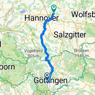
Hausrund
A cycling route starting in Rosdorf, Lower Saxony, Germany.
Overview
About this route
Short nice ride. Try not to use it during peak traffic times, as some country roads are part of the route. From Varmissen, one could ride through Dransfeld and then extend the route over Hohen Hagen. The road is mostly good and there are a few bike paths and relatively little traffic. From Groß Ellershausen to Olenhusen, the asphalt is not very good, but it is passable without getting a flat.
- -:--
- Duration
- 34.2 km
- Distance
- 351 m
- Ascent
- 338 m
- Descent
- ---
- Avg. speed
- 417 m
- Max. altitude
Route quality
Waytypes & surfaces along the route
Waytypes
Road
15.7 km
(46 %)
Quiet road
5.1 km
(15 %)
Surfaces
Paved
33.5 km
(98 %)
Unpaved
0.3 km
(1 %)
Asphalt
33.5 km
(98 %)
Gravel
0.3 km
(1 %)
Undefined
0.3 km
(1 %)
Continue with Bikemap
Use, edit, or download this cycling route
You would like to ride Hausrund or customize it for your own trip? Here is what you can do with this Bikemap route:
Free features
- Save this route as favorite or in collections
- Copy & plan your own version of this route
- Sync your route with Garmin or Wahoo
Premium features
Free trial for 3 days, or one-time payment. More about Bikemap Premium.
- Navigate this route on iOS & Android
- Export a GPX / KML file of this route
- Create your custom printout (try it for free)
- Download this route for offline navigation
Discover more Premium features.
Get Bikemap PremiumFrom our community
Other popular routes starting in Rosdorf
 Gö_Meißner_Friedland_Hoher Hagen_Gö
- Distance
- 171.4 km
- Ascent
- 2,290 m
- Descent
- 2,193 m
- Location
- Rosdorf, Lower Saxony, Germany
 2015-04-20 ASC-Senioren
- Distance
- 25.7 km
- Ascent
- 12 m
- Descent
- 30 m
- Location
- Rosdorf, Lower Saxony, Germany
 EAM-ebike-Fahrt 01.09.2016
- Distance
- 27.8 km
- Ascent
- 224 m
- Descent
- 224 m
- Location
- Rosdorf, Lower Saxony, Germany
 Rosdorf - Varmissen - Dransfeld - Hoher Hagen - Jühnde - Volkerode und zurück
- Distance
- 38.3 km
- Ascent
- 373 m
- Descent
- 373 m
- Location
- Rosdorf, Lower Saxony, Germany
 Rosdorf - Höxter
- Distance
- 139.5 km
- Ascent
- 548 m
- Descent
- 736 m
- Location
- Rosdorf, Lower Saxony, Germany
 Gö.-Reinhardswald-Hemeln-Hoher Hagen-Gö
- Distance
- 103.4 km
- Ascent
- 1,127 m
- Descent
- 1,127 m
- Location
- Rosdorf, Lower Saxony, Germany
 ZFC 2011 Rosdorf CLONED FROM ROUTE 745758
- Distance
- 12.7 km
- Ascent
- 48 m
- Descent
- 38 m
- Location
- Rosdorf, Lower Saxony, Germany
 Wakenbreite 15, Göttingen to Maschmühlenweg 64C, Göttingen
- Distance
- 8.1 km
- Ascent
- 29 m
- Descent
- 153 m
- Location
- Rosdorf, Lower Saxony, Germany
Open it in the app