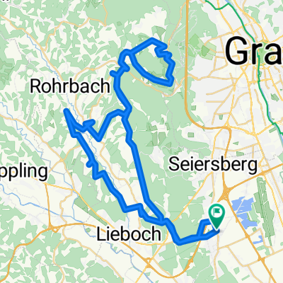
Die Südrunde
A cycling route starting in Unterpremstätten, Styria, Austria.
Overview
About this route
ridden on: 02.03.2012
net ride time: 2:06:10
entirely on secondary roads or cycle paths
- -:--
- Duration
- 55.7 km
- Distance
- 159 m
- Ascent
- 159 m
- Descent
- ---
- Avg. speed
- ---
- Max. altitude
Route quality
Waytypes & surfaces along the route
Waytypes
Quiet road
31.8 km
(57 %)
Cycleway
5 km
(9 %)
Surfaces
Paved
34.6 km
(62 %)
Unpaved
0.6 km
(1 %)
Asphalt
34.6 km
(62 %)
Ground
0.6 km
(1 %)
Undefined
20.6 km
(37 %)
Continue with Bikemap
Use, edit, or download this cycling route
You would like to ride Die Südrunde or customize it for your own trip? Here is what you can do with this Bikemap route:
Free features
- Save this route as favorite or in collections
- Copy & plan your own version of this route
- Sync your route with Garmin or Wahoo
Premium features
Free trial for 3 days, or one-time payment. More about Bikemap Premium.
- Navigate this route on iOS & Android
- Export a GPX / KML file of this route
- Create your custom printout (try it for free)
- Download this route for offline navigation
Discover more Premium features.
Get Bikemap PremiumFrom our community
Other popular routes starting in Unterpremstätten
Schwarzlsee - Wildon - Kirchberg - St. Margarethen - Nestelbach - Schwarzlsee- Distance
- 88.4 km
- Ascent
- 946 m
- Descent
- 953 m
- Location
- Unterpremstätten, Styria, Austria
Südsteiermark- Distance
- 90.1 km
- Ascent
- 528 m
- Descent
- 636 m
- Location
- Unterpremstätten, Styria, Austria
Steiermark 3 - Südliche Mur- Distance
- 76.7 km
- Ascent
- 172 m
- Descent
- 176 m
- Location
- Unterpremstätten, Styria, Austria
UP-Feldkirchen-Graz-Thal/Eben-Steinberg-Hitzendorf-Doblegg-Tobelbad-Dobl-Zwaring-Wundschuh-SFZ- Distance
- 64.8 km
- Ascent
- 420 m
- Descent
- 438 m
- Location
- Unterpremstätten, Styria, Austria
Über die süd-westl Hügeln- Distance
- 54 km
- Ascent
- 564 m
- Descent
- 564 m
- Location
- Unterpremstätten, Styria, Austria
Steiermark 2 - Westl. Steiermark- Distance
- 56.4 km
- Ascent
- 535 m
- Descent
- 535 m
- Location
- Unterpremstätten, Styria, Austria
Die West-Tour- Distance
- 76.9 km
- Ascent
- 1,066 m
- Descent
- 1,064 m
- Location
- Unterpremstätten, Styria, Austria
Kalsdorf - Muttendorf - Dobl - Unterpremstätten- Distance
- 46.9 km
- Ascent
- 239 m
- Descent
- 249 m
- Location
- Unterpremstätten, Styria, Austria
Open it in the app

