

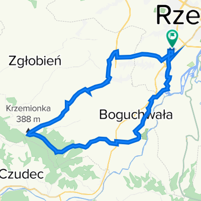
04.03.2012
A cycling route starting in Kielanówka, Subcarpathian Voivodeship, Poland.
Overview
About this route
Z Dziadkiem, Kokilem, Mikim. 3,5h, zajechany.
- -:--
- Duration
- 93.7 km
- Distance
- 323 m
- Ascent
- 323 m
- Descent
- ---
- Avg. speed
- ---
- Max. altitude

Route quality
Waytypes & surfaces along the route
Waytypes
Road
25.3 km
(27 %)
Quiet road
7.5 km
(8 %)
Surfaces
Paved
75 km
(80 %)
Asphalt
72.2 km
(77 %)
Paved (undefined)
2.8 km
(3 %)
Undefined
18.7 km
(20 %)
Continue with Bikemap
Use, edit, or download this cycling route
You would like to ride 04.03.2012 or customize it for your own trip? Here is what you can do with this Bikemap route:
Free features
- Save this route as favorite or in collections
- Copy & plan your own version of this route
- Split it into stages to create a multi-day tour
- Sync your route with Garmin or Wahoo
Premium features
Free trial for 3 days, or one-time payment. More about Bikemap Premium.
- Navigate this route on iOS & Android
- Export a GPX / KML file of this route
- Create your custom printout (try it for free)
- Download this route for offline navigation
Discover more Premium features.
Get Bikemap PremiumFrom our community
Other popular routes starting in Kielanówka
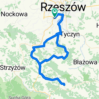
 Architektów-Rezerwat-Siedliska-Architektow
- Distance
- 51.7 km
- Ascent
- 573 m
- Descent
- 574 m
- Location
- Kielanówka, Subcarpathian Voivodeship, Poland
 2013/11 Rzeszów Kresowa - Niechobrz Górny
- Distance
- 24.8 km
- Ascent
- 244 m
- Descent
- 245 m
- Location
- Kielanówka, Subcarpathian Voivodeship, Poland
 Architektów-Krzemionka-Architektów
- Distance
- 29.6 km
- Ascent
- 285 m
- Descent
- 290 m
- Location
- Kielanówka, Subcarpathian Voivodeship, Poland
 07.04.2012
- Distance
- 84.9 km
- Ascent
- 517 m
- Descent
- 517 m
- Location
- Kielanówka, Subcarpathian Voivodeship, Poland
 Strzyżów oraz Wielopole z Zagorzycami
- Distance
- 80.7 km
- Ascent
- 553 m
- Descent
- 582 m
- Location
- Kielanówka, Subcarpathian Voivodeship, Poland
 04.03.2012
- Distance
- 93.7 km
- Ascent
- 323 m
- Descent
- 323 m
- Location
- Kielanówka, Subcarpathian Voivodeship, Poland
 Boguchwała, Lutoryż i las Lutoryski
- Distance
- 30.5 km
- Ascent
- 316 m
- Descent
- 316 m
- Location
- Kielanówka, Subcarpathian Voivodeship, Poland
 Makowa 2, Rzeszów do Ciepłownicza 8B, Rzeszów
- Distance
- 8.1 km
- Ascent
- 36 m
- Descent
- 74 m
- Location
- Kielanówka, Subcarpathian Voivodeship, Poland
Open it in the app