

Frankreich 2024
F121-2024-Chanac-Quezac-Saint Emine-Chanac
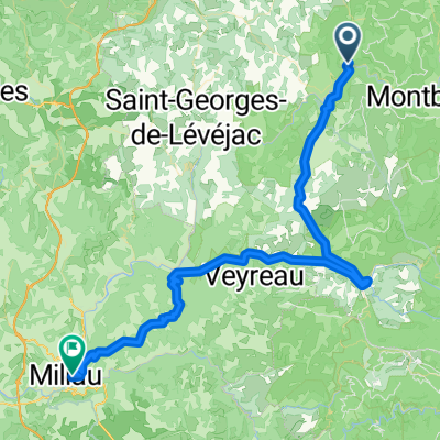
A cycling route starting in Chanac, Occitanie, France.
Overview
About this route
- 3 h 37 min
- Duration
- 63.4 km
- Distance
- 2,103 m
- Ascent
- 2,109 m
- Descent
- 17.6 km/h
- Avg. speed
- 1,024 m
- Max. altitude

Part of
Frankreich 2024
1 stage
Route quality
Waytypes & surfaces along the route
Waytypes
Road
17.1 km
(27 %)
Undefined
46.3 km
(73 %)
Surfaces
Paved
24.1 km
(38 %)
Asphalt
24.1 km
(38 %)
Undefined
39.3 km
(62 %)
Continue with Bikemap
Use, edit, or download this cycling route
You would like to ride F121-2024-Chanac-Quezac-Saint Emine-Chanac or customize it for your own trip? Here is what you can do with this Bikemap route:
Free features
- Save this route as favorite or in collections
- Copy & plan your own version of this route
- Sync your route with Garmin or Wahoo
Premium features
Free trial for 3 days, or one-time payment. More about Bikemap Premium.
- Navigate this route on iOS & Android
- Export a GPX / KML file of this route
- Create your custom printout (try it for free)
- Download this route for offline navigation
Discover more Premium features.
Get Bikemap PremiumFrom our community
Other popular routes starting in Chanac
 F124-2024-Chanac-Einrollen-Trekking
- Distance
- 58.7 km
- Ascent
- 1,670 m
- Descent
- 1,670 m
- Location
- Chanac, Occitanie, France
 F122-2024-Chanac-Florac-Les Vignes-La Malene-Chanac
- Distance
- 118.7 km
- Ascent
- 3,462 m
- Descent
- 3,474 m
- Location
- Chanac, Occitanie, France
 Ride Day 31—12 Oct 2005—48210 St-Chely du Tarn/Sainte Énimie to 48260 Recoules D'Aubrac (Nasbinals)
- Distance
- 86.1 km
- Ascent
- 1,224 m
- Descent
- 644 m
- Location
- Chanac, Occitanie, France
 Tarnroute (Nr. 160) Ste. Enemie- Millau
- Distance
- 55.4 km
- Ascent
- 318 m
- Descent
- 436 m
- Location
- Chanac, Occitanie, France
 Entre Culture et le Monastier
- Distance
- 36.7 km
- Ascent
- 580 m
- Descent
- 583 m
- Location
- Chanac, Occitanie, France
 F123-2024-Chanac-Correjac-Le Balmes-Chanac
- Distance
- 42.9 km
- Ascent
- 1,243 m
- Descent
- 1,244 m
- Location
- Chanac, Occitanie, France
 F125-2024-Chanac-La Tieule-Chanac
- Distance
- 65.1 km
- Ascent
- 1,794 m
- Descent
- 1,798 m
- Location
- Chanac, Occitanie, France
 Ste. Enimie - Millau (Causse Route nr. 159)
- Distance
- 76.7 km
- Ascent
- 1,119 m
- Descent
- 1,262 m
- Location
- Chanac, Occitanie, France
Open it in the app