

Dunstable Doo-Dah 70-miler
A cycling route starting in Lexington, Massachusetts, United States.
Overview
About this route
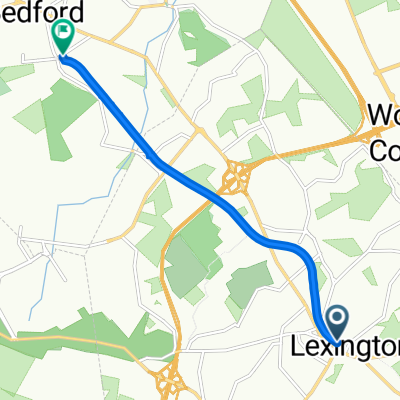
North to Dunstable and Hollis, NH, south to Pepperell, Groton, Ayer, Nagog Hill, Strawberry Hill, Concord, and home.
Alternate version: go from Hollis to Ayer on the Nashua River Rail-Trail.
- -:--
- Duration
- 108.3 km
- Distance
- 739 m
- Ascent
- 737 m
- Descent
- ---
- Avg. speed
- 118 m
- Max. altitude

Route quality
Waytypes & surfaces along the route
Waytypes
Road
42.2 km
(39 %)
Quiet road
32.5 km
(30 %)
Surfaces
Paved
58.5 km
(54 %)
Asphalt
58.5 km
(54 %)
Undefined
49.8 km
(46 %)
Continue with Bikemap
Use, edit, or download this cycling route
You would like to ride Dunstable Doo-Dah 70-miler or customize it for your own trip? Here is what you can do with this Bikemap route:
Free features
- Save this route as favorite or in collections
- Copy & plan your own version of this route
- Split it into stages to create a multi-day tour
- Sync your route with Garmin or Wahoo
Premium features
Free trial for 3 days, or one-time payment. More about Bikemap Premium.
- Navigate this route on iOS & Android
- Export a GPX / KML file of this route
- Create your custom printout (try it for free)
- Download this route for offline navigation
Discover more Premium features.
Get Bikemap PremiumFrom our community
Other popular routes starting in Lexington
 Lexington/Carlisle Sunday Longer Ride
- Distance
- 60.9 km
- Ascent
- 278 m
- Descent
- 280 m
- Location
- Lexington, Massachusetts, United States
 Concord-Strawberry Hill-Carlisle
- Distance
- 50.6 km
- Ascent
- 375 m
- Descent
- 374 m
- Location
- Lexington, Massachusetts, United States
 Minuteman Commuter Bikeway, Lexington to 74 Loomis St, Bedford
- Distance
- 6.2 km
- Ascent
- 20 m
- Descent
- 50 m
- Location
- Lexington, Massachusetts, United States
 half lex loop
- Distance
- 30.9 km
- Ascent
- 141 m
- Descent
- 140 m
- Location
- Lexington, Massachusetts, United States
 Verrill Farm Loop
- Distance
- 54 km
- Ascent
- 406 m
- Descent
- 431 m
- Location
- Lexington, Massachusetts, United States
 Liberty Square 50-miler
- Distance
- 85.5 km
- Ascent
- 509 m
- Descent
- 522 m
- Location
- Lexington, Massachusetts, United States
 Dunstable Doo-Dah 70-miler
- Distance
- 108.3 km
- Ascent
- 739 m
- Descent
- 737 m
- Location
- Lexington, Massachusetts, United States
 26 Hancock St, Lexington to 26 Hancock St, Lexington
- Distance
- 29.3 km
- Ascent
- 90 m
- Descent
- 90 m
- Location
- Lexington, Massachusetts, United States
Open it in the app