
Köpenick-Schlenker
A cycling route starting in Kreuzberg, Land Berlin, Germany.
Overview
About this route
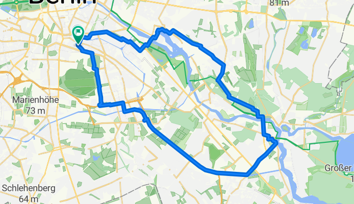
So grün es geht gen Osten raus aus Kreuzberg. Über die Fussgänger-Elsenbrücke, am DB Riegel vorbei, der die hautevolee Halbinsel Stralau betort, an der Rummelsburger Bucht vorbei und dann hoch richtung Funkhaus Nalepastraße wo man am Wasser im Kulturhafen Rummelsburg oder an der Milchbar hinterm Funkhaus Rasten kann. Beeindruckender Ort und bis 2020 noch nicht so überlaufen gewesen Sonntags. Die Wilhelminenhofstraße ist so eine Art Industriedenkmal, dort hat Wilhem Rathenau angefangen, Industrie anzusiedeln (AEG später) zu einer Zeit, wo man mit Klinker baute und mit hohen Fenstern Sonnenlicht fangen musste. Naja, und der Rückweg ist halt die oft von Rennradfahrern und Skatern genutzte "Ostkrone" (vs. Kronprinzessinnenweg an der Avus).
- 2 h 14 min
- Duration
- 35.8 km
- Distance
- 84 m
- Ascent
- 82 m
- Descent
- 16 km/h
- Avg. speed
- 54 m
- Max. altitude

Route quality
Waytypes & surfaces along the route
Waytypes
Cycleway
9.1 km
(25 %)
Pedestrian area
6.7 km
(19 %)
Surfaces
Paved
26.7 km
(75 %)
Unpaved
1 km
(3 %)
Asphalt
24.8 km
(69 %)
Concrete
1.1 km
(3 %)
Continue with Bikemap
Use, edit, or download this cycling route
You would like to ride Köpenick-Schlenker or customize it for your own trip? Here is what you can do with this Bikemap route:
Free features
- Save this route as favorite or in collections
- Copy & plan your own version of this route
- Sync your route with Garmin or Wahoo
Premium features
Free trial for 3 days, or one-time payment. More about Bikemap Premium.
- Navigate this route on iOS & Android
- Export a GPX / KML file of this route
- Create your custom printout (try it for free)
- Download this route for offline navigation
Discover more Premium features.
Get Bikemap PremiumFrom our community
Other popular routes starting in Kreuzberg
 Route in Berlin
- Distance
- 67.4 km
- Ascent
- 167 m
- Descent
- 160 m
- Location
- Kreuzberg, Land Berlin, Germany
 Kleine Havelrunde
- Distance
- 51.1 km
- Ascent
- 171 m
- Descent
- 171 m
- Location
- Kreuzberg, Land Berlin, Germany
 Berlin Schweiz
- Distance
- 1,184.4 km
- Ascent
- 7,260 m
- Descent
- 6,642 m
- Location
- Kreuzberg, Land Berlin, Germany
 Trainingsrunde um Sacrow kurze Verion
- Distance
- 80.5 km
- Ascent
- 351 m
- Descent
- 353 m
- Location
- Kreuzberg, Land Berlin, Germany
 Kreuzberg to Treptow
- Distance
- 19.9 km
- Ascent
- 48 m
- Descent
- 46 m
- Location
- Kreuzberg, Land Berlin, Germany
 Grünaurunde
- Distance
- 67.4 km
- Ascent
- 126 m
- Descent
- 131 m
- Location
- Kreuzberg, Land Berlin, Germany
 Meine Grunewaldrunde
- Distance
- 43.3 km
- Ascent
- 155 m
- Descent
- 155 m
- Location
- Kreuzberg, Land Berlin, Germany
 Trainingsrunde1
- Distance
- 90.3 km
- Ascent
- 299 m
- Descent
- 292 m
- Location
- Kreuzberg, Land Berlin, Germany
Open it in the app