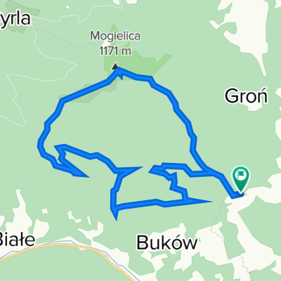
Mogielnica - W.Wierch - AP
A cycling route starting in SÅopnice, Lesser Poland Voivodeship, Poland.
Overview
About this route
Nowy SÄ cz âPrzeÅÄcz SÅopnicka (samochodem) â Zielony szlak pieszy i niebieski rowerowy na MogielnicÄ â Mogielnica â PrzeÅÄcz PrzysÅopek â PrzeÅÄcz SÅopnicka â Nowy SÄ cz (samochodem)
- 2 h 20 min
- Duration
- 26.1 km
- Distance
- 1,436 m
- Ascent
- 1,436 m
- Descent
- 11.2 km/h
- Avg. speed
- 1,147 m
- Avg. speed
Route quality
Waytypes & surfaces along the route
Waytypes
Track
10.5 km
(40 %)
Quiet road
9.8 km
(38 %)
Surfaces
Paved
5 km
(19 %)
Unpaved
10.6 km
(40 %)
Ground
5.1 km
(20 %)
Gravel
3.1 km
(12 %)
Continue with Bikemap
Use, edit, or download this cycling route
You would like to ride Mogielnica - W.Wierch - AP or customize it for your own trip? Here is what you can do with this Bikemap route:
Free features
- Save this route as favorite or in collections
- Copy & plan your own version of this route
- Sync your route with Garmin or Wahoo
Premium features
Free trial for 3 days, or one-time payment. More about Bikemap Premium.
- Navigate this route on iOS & Android
- Export a GPX / KML file of this route
- Create your custom printout (try it for free)
- Download this route for offline navigation
Discover more Premium features.
Get Bikemap PremiumFrom our community
Other popular routes starting in SÅopnice
- Okolice Limanowej
- Distance
- 316.8 km
- Ascent
- 4,516 m
- Descent
- 4,516 m
- Location
- SÅopnice, Lesser Poland Voivodeship, Poland
- WOKÃÅ MOGIELICY
- Distance
- 33.4 km
- Ascent
- 868 m
- Descent
- 869 m
- Location
- SÅopnice, Lesser Poland Voivodeship, Poland
- WokóŠMogielicy - light
- Distance
- 22.5 km
- Ascent
- 627 m
- Descent
- 625 m
- Location
- SÅopnice, Lesser Poland Voivodeship, Poland
- Mogielica - petla
- Distance
- 44.2 km
- Ascent
- 1,047 m
- Descent
- 1,047 m
- Location
- SÅopnice, Lesser Poland Voivodeship, Poland
- 2017.02.11 UC FateBake - PodÅopieÅ
- Distance
- 28.1 km
- Ascent
- 726 m
- Descent
- 1,119 m
- Location
- SÅopnice, Lesser Poland Voivodeship, Poland
- Mogielnica - W.Wierch - AP
- Distance
- 26.1 km
- Ascent
- 1,436 m
- Descent
- 1,436 m
- Location
- SÅopnice, Lesser Poland Voivodeship, Poland
- wokol lopienia
- Distance
- 15.3 km
- Ascent
- 498 m
- Descent
- 498 m
- Location
- SÅopnice, Lesser Poland Voivodeship, Poland
- Mogielica
- Distance
- 15.1 km
- Ascent
- 725 m
- Descent
- 725 m
- Location
- SÅopnice, Lesser Poland Voivodeship, Poland