

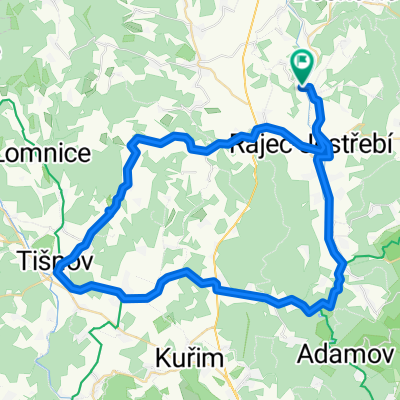
nenáročná stovka přes Sloup, Blansko, Boskovice, Lysice atd.
A cycling route starting in Doubravice nad Svitavou, South Moravian, Czechia.
Overview
About this route
As usual, a road route aimed at riding as little as possible the same way back and forth. A pleasant route with minimal hills, suitable for example for an afternoon ride.
- -:--
- Duration
- 100.5 km
- Distance
- 1,595 m
- Ascent
- 1,664 m
- Descent
- ---
- Avg. speed
- 624 m
- Max. altitude
Route quality
Waytypes & surfaces along the route
Waytypes
Road
39.2 km
(39 %)
Quiet road
9 km
(9 %)
Surfaces
Paved
61.3 km
(61 %)
Asphalt
61.3 km
(61 %)
Undefined
39.2 km
(39 %)
Continue with Bikemap
Use, edit, or download this cycling route
You would like to ride nenáročná stovka přes Sloup, Blansko, Boskovice, Lysice atd. or customize it for your own trip? Here is what you can do with this Bikemap route:
Free features
- Save this route as favorite or in collections
- Copy & plan your own version of this route
- Split it into stages to create a multi-day tour
- Sync your route with Garmin or Wahoo
Premium features
Free trial for 3 days, or one-time payment. More about Bikemap Premium.
- Navigate this route on iOS & Android
- Export a GPX / KML file of this route
- Create your custom printout (try it for free)
- Download this route for offline navigation
Discover more Premium features.
Get Bikemap PremiumFrom our community
Other popular routes starting in Doubravice nad Svitavou
 lehká odpočinková trasa v okolí Obory
- Distance
- 22.3 km
- Ascent
- 159 m
- Descent
- 226 m
- Location
- Doubravice nad Svitavou, South Moravian, Czechia
 Doubravice nad Svitavou - Býkovice
- Distance
- 12.9 km
- Ascent
- 158 m
- Descent
- 102 m
- Location
- Doubravice nad Svitavou, South Moravian, Czechia
 Doubravice n.S. - Boskovice - Jaroměřice - Loštice
- Distance
- 50.4 km
- Ascent
- 641 m
- Descent
- 662 m
- Location
- Doubravice nad Svitavou, South Moravian, Czechia
 ČH - Tišnov - BK
- Distance
- 61.2 km
- Ascent
- 491 m
- Descent
- 490 m
- Location
- Doubravice nad Svitavou, South Moravian, Czechia
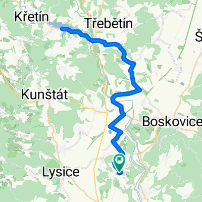 lehká projížďka na Křetinku
- Distance
- 42.7 km
- Ascent
- 607 m
- Descent
- 636 m
- Location
- Doubravice nad Svitavou, South Moravian, Czechia
 nenáročná trasa Obora - Chudčice - Blansko - Obora
- Distance
- 83.9 km
- Ascent
- 1,177 m
- Descent
- 1,281 m
- Location
- Doubravice nad Svitavou, South Moravian, Czechia
 nfbfgf
- Distance
- 100.9 km
- Ascent
- 1,410 m
- Descent
- 1,409 m
- Location
- Doubravice nad Svitavou, South Moravian, Czechia
 Doubravice nad Svitavou, Brno
- Distance
- 65.2 km
- Ascent
- 476 m
- Descent
- 558 m
- Location
- Doubravice nad Svitavou, South Moravian, Czechia
Open it in the app