
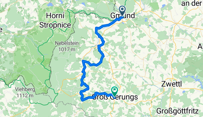
Bahnhof Gmünd # Granittrail Waldviertel - Groß Gerungs
A cycling route starting in Gmünd, Lower Austria, Austria.
Overview
About this route
- 4 h 8 min
- Duration
- 55.1 km
- Distance
- 1,206 m
- Ascent
- 1,024 m
- Descent
- 13.3 km/h
- Avg. speed
- 929 m
- Avg. speed
Route quality
Waytypes & surfaces along the route
Waytypes
Track
21.8 km
(40 %)
Road
15.3 km
(28 %)
Surfaces
Paved
21 km
(38 %)
Unpaved
13.9 km
(25 %)
Asphalt
15.3 km
(28 %)
Gravel
9 km
(16 %)
Continue with Bikemap
Use, edit, or download this cycling route
You would like to ride Bahnhof Gmünd # Granittrail Waldviertel - Groß Gerungs or customize it for your own trip? Here is what you can do with this Bikemap route:
Free features
- Save this route as favorite or in collections
- Copy & plan your own version of this route
- Sync your route with Garmin or Wahoo
Premium features
Free trial for 3 days, or one-time payment. More about Bikemap Premium.
- Navigate this route on iOS & Android
- Export a GPX / KML file of this route
- Create your custom printout (try it for free)
- Download this route for offline navigation
Discover more Premium features.
Get Bikemap PremiumFrom our community
Other popular routes starting in Gmünd
 Trainingsstrecke_1
- Distance
- 57.4 km
- Ascent
- 433 m
- Descent
- 437 m
- Location
- Gmünd, Lower Austria, Austria
 gmünd-krumau-gmünd-krems
- Distance
- 354 km
- Ascent
- 9,631 m
- Descent
- 9,931 m
- Location
- Gmünd, Lower Austria, Austria
 Dresden W9 E3 (Gmünd Blockheide)
- Distance
- 16 km
- Ascent
- 249 m
- Descent
- 250 m
- Location
- Gmünd, Lower Austria, Austria
 Wasserlandschaft 24.09
- Distance
- 80 km
- Ascent
- 790 m
- Descent
- 784 m
- Location
- Gmünd, Lower Austria, Austria
 NatUrknallweg
- Distance
- 26.4 km
- Ascent
- 157 m
- Descent
- 154 m
- Location
- Gmünd, Lower Austria, Austria
 Teichrunde
- Distance
- 81 km
- Ascent
- 238 m
- Descent
- 236 m
- Location
- Gmünd, Lower Austria, Austria
 Mandelstein-Sulz-Weitra
- Distance
- 48.2 km
- Ascent
- 566 m
- Descent
- 566 m
- Location
- Gmünd, Lower Austria, Austria
 Route bei Gmünd
- Distance
- 17.3 km
- Ascent
- 213 m
- Descent
- 213 m
- Location
- Gmünd, Lower Austria, Austria
Open it in the app