

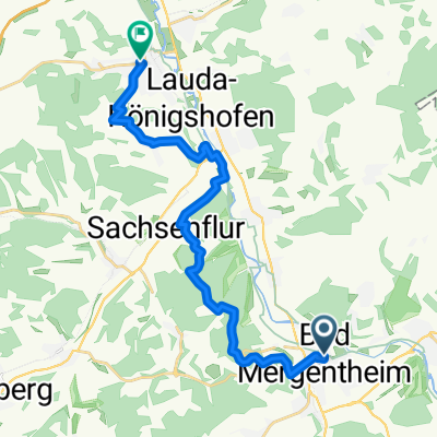
Lorenz-Fries-Straße 3, Bad Mergentheim do Uiffinger Straße 74, Boxberg
A cycling route starting in Bad Mergentheim, Baden-Wurttemberg, Germany.
Overview
About this route
- 58 min
- Duration
- 21 km
- Distance
- 122 m
- Ascent
- 69 m
- Descent
- 21.7 km/h
- Avg. speed
- 263 m
- Max. altitude
Route quality
Waytypes & surfaces along the route
Waytypes
Track
6.5 km
(31 %)
Quiet road
6.1 km
(29 %)
Surfaces
Paved
19.7 km
(94 %)
Asphalt
19.5 km
(93 %)
Paved (undefined)
0.2 km
(1 %)
Undefined
1.3 km
(6 %)
Continue with Bikemap
Use, edit, or download this cycling route
You would like to ride Lorenz-Fries-Straße 3, Bad Mergentheim do Uiffinger Straße 74, Boxberg or customize it for your own trip? Here is what you can do with this Bikemap route:
Free features
- Save this route as favorite or in collections
- Copy & plan your own version of this route
- Sync your route with Garmin or Wahoo
Premium features
Free trial for 3 days, or one-time payment. More about Bikemap Premium.
- Navigate this route on iOS & Android
- Export a GPX / KML file of this route
- Create your custom printout (try it for free)
- Download this route for offline navigation
Discover more Premium features.
Get Bikemap PremiumFrom our community
Other popular routes starting in Bad Mergentheim
 Keltentour
- Distance
- 90.2 km
- Ascent
- 817 m
- Descent
- 815 m
- Location
- Bad Mergentheim, Baden-Wurttemberg, Germany
 Taubertal-Panorama Teil 2
- Distance
- 18.3 km
- Ascent
- 432 m
- Descent
- 444 m
- Location
- Bad Mergentheim, Baden-Wurttemberg, Germany
 Rundtour zum Rand des Steigerwaldes
- Distance
- 165.5 km
- Ascent
- 1,440 m
- Descent
- 1,370 m
- Location
- Bad Mergentheim, Baden-Wurttemberg, Germany
 Streuobstwiesen-Tour
- Distance
- 34 km
- Ascent
- 275 m
- Descent
- 272 m
- Location
- Bad Mergentheim, Baden-Wurttemberg, Germany
 Weinbau-Tour
- Distance
- 79.5 km
- Ascent
- 908 m
- Descent
- 905 m
- Location
- Bad Mergentheim, Baden-Wurttemberg, Germany
 Rothenburg o.T. - Berchtesgaden
- Distance
- 857.9 km
- Ascent
- 738 m
- Descent
- 370 m
- Location
- Bad Mergentheim, Baden-Wurttemberg, Germany
 Grünkern-Tour
- Distance
- 51.4 km
- Ascent
- 684 m
- Descent
- 685 m
- Location
- Bad Mergentheim, Baden-Wurttemberg, Germany
 HE02-Mergentheim-Colmberg
- Distance
- 67.8 km
- Ascent
- 450 m
- Descent
- 210 m
- Location
- Bad Mergentheim, Baden-Wurttemberg, Germany
Open it in the app