

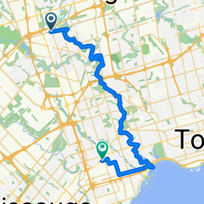
Downsview Park to Wellesley Station Via West Humber, Etobicoke Creek, Centennial Park, Beltline, Taylor Creek, Board Walk, Tommy Thompson, Riverdale Farm
A cycling route starting in Concord, Ontario, Canada.
Overview
About this route
100 KM 10 hour slow bike ride. (730 AM to 530 PM) on paved trials through parks and forest along Rivers and Creeks.
Downsview to Wellesley Station Via West Humber, Etobicoke Creek, Centennial Park, Beltline, Taylor Creek, Boardwalk, Tommy Thompson, Riverdale Farm,
- 6 h 14 min
- Duration
- 98.5 km
- Distance
- 532 m
- Ascent
- 613 m
- Descent
- 15.8 km/h
- Avg. speed
- 196 m
- Max. altitude

Route quality
Waytypes & surfaces along the route
Waytypes
Cycleway
40.6 km
(41 %)
Quiet road
21.2 km
(22 %)
Surfaces
Paved
83.9 km
(85 %)
Unpaved
4.4 km
(4 %)
Asphalt
81.1 km
(82 %)
Gravel
3.9 km
(4 %)
Continue with Bikemap
Use, edit, or download this cycling route
You would like to ride Downsview Park to Wellesley Station Via West Humber, Etobicoke Creek, Centennial Park, Beltline, Taylor Creek, Board Walk, Tommy Thompson, Riverdale Farm or customize it for your own trip? Here is what you can do with this Bikemap route:
Free features
- Save this route as favorite or in collections
- Copy & plan your own version of this route
- Split it into stages to create a multi-day tour
- Sync your route with Garmin or Wahoo
Premium features
Free trial for 3 days, or one-time payment. More about Bikemap Premium.
- Navigate this route on iOS & Android
- Export a GPX / KML file of this route
- Create your custom printout (try it for free)
- Download this route for offline navigation
Discover more Premium features.
Get Bikemap PremiumFrom our community
Other popular routes starting in Concord
 Downsview Park to Claireville Ranch and BAPS
- Distance
- 50.2 km
- Ascent
- 306 m
- Descent
- 307 m
- Location
- Concord, Ontario, Canada
 Humber Recreational Trail
- Distance
- 24.5 km
- Ascent
- 73 m
- Descent
- 143 m
- Location
- Concord, Ontario, Canada
 humber river
- Distance
- 37.1 km
- Ascent
- 397 m
- Descent
- 455 m
- Location
- Concord, Ontario, Canada
 San Gabriele Place 9, Toronto to Stanley Avenue 5879-5899, Niagara Falls
- Distance
- 136 km
- Ascent
- 563 m
- Descent
- 526 m
- Location
- Concord, Ontario, Canada
 Vaughan station to Kortright conservation park
- Distance
- 31.1 km
- Ascent
- 475 m
- Descent
- 475 m
- Location
- Concord, Ontario, Canada
 Downsview Park to Malton Via West Humber and Claireville Ranch
- Distance
- 45.3 km
- Ascent
- 255 m
- Descent
- 279 m
- Location
- Concord, Ontario, Canada
 De Shoreham Drive 30, Toronto a Martin Goodman Trail, Toronto
- Distance
- 27.3 km
- Ascent
- 260 m
- Descent
- 369 m
- Location
- Concord, Ontario, Canada
 kcc100
- Distance
- 105.2 km
- Ascent
- 345 m
- Descent
- 343 m
- Location
- Concord, Ontario, Canada
Open it in the app