

편안한 경로
A cycling route starting in Wabu, Gyeonggi-do, South Korea.
Overview
About this route
- 19 min
- Duration
- 3.8 km
- Distance
- 6 m
- Ascent
- 28 m
- Descent
- 12.2 km/h
- Avg. speed
- 42 m
- Max. altitude
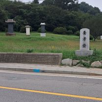
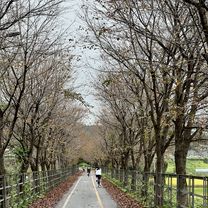
Route photos

Route quality
Waytypes & surfaces along the route
Waytypes
Cycleway
3.8 km
(100 %)
Surfaces
Paved
3.8 km
(100 %)
Concrete
3.8 km
(100 %)
Continue with Bikemap
Use, edit, or download this cycling route
You would like to ride 편안한 경로 or customize it for your own trip? Here is what you can do with this Bikemap route:
Free features
- Save this route as favorite or in collections
- Copy & plan your own version of this route
- Sync your route with Garmin or Wahoo
Premium features
Free trial for 3 days, or one-time payment. More about Bikemap Premium.
- Navigate this route on iOS & Android
- Export a GPX / KML file of this route
- Create your custom printout (try it for free)
- Download this route for offline navigation
Discover more Premium features.
Get Bikemap PremiumFrom our community
Other popular routes starting in Wabu
 bukhangang path
- Distance
- 71.9 km
- Ascent
- 259 m
- Descent
- 214 m
- Location
- Wabu, Gyeonggi-do, South Korea
 양수역-벗고개-서후리-어비계곡-설매재-양수역
- Distance
- 58 km
- Ascent
- 1,616 m
- Descent
- 1,617 m
- Location
- Wabu, Gyeonggi-do, South Korea
 편안한 경로
- Distance
- 3.8 km
- Ascent
- 6 m
- Descent
- 28 m
- Location
- Wabu, Gyeonggi-do, South Korea
 조안면 85-2 ~ 조안면 285-1
- Distance
- 18.7 km
- Ascent
- 315 m
- Descent
- 329 m
- Location
- Wabu, Gyeonggi-do, South Korea
 Sulmajae-Bukgogae
- Distance
- 123.5 km
- Ascent
- 2,193 m
- Descent
- 2,160 m
- Location
- Wabu, Gyeonggi-do, South Korea
 남양주 예봉산
- Distance
- 58.3 km
- Ascent
- 1,993 m
- Descent
- 1,983 m
- Location
- Wabu, Gyeonggi-do, South Korea
 양평군에서 천서리, 여주시까지
- Distance
- 33.7 km
- Ascent
- 305 m
- Descent
- 293 m
- Location
- Wabu, Gyeonggi-do, South Korea
 동부8고개
동부8고개- Distance
- 93.9 km
- Ascent
- 1,372 m
- Descent
- 1,339 m
- Location
- Wabu, Gyeonggi-do, South Korea
Open it in the app